This week was broken up by a trip to Austin, Texas, for a conference, but I actually got in quite a bit of good running.
Mon: Cortland road run (3.4 mi)
An easy run around town before catching my flight to Austin.
Tues: rest/acclimation to crazy Texas heat
Wed: Trail/road run/getting lost in Austin (~10 mi)
This was an interesting adventure. Check out this post for a full description.
Thurs: rest/flying back to nice, cool central New York
Fri: Trail run at Lime Hollow (~6.5 mi)
Ah, it's nice to be back in sub-100 degree temperatures. This was a beautiful day and I had a great run on an extended version of the Bog-Wilderness Loop.
Sat: Finger Lakes Trail in Hammond Hill and Robinson Hollow S.F. (15.2 mi, 2740 ft gain)
I drove out to Dryden to check out a new segment of the Finger Lakes Trail that crosses two state forests (Hammond Hill and Robinson Hollow) and two counties (Tompkins and Tioga). Check out this page from cnyhiking.com for a map.
The run began with a 700+ foot climb from NY Route 38 to the microwave tower on Hammond Hill. For the first part of the climb, the FLT follows Star Stanton Road, which is initially paved but soon turns to dirt and becomes increasingly washed out- don't try to drive here. At the top of the plateau, the trail turns into single track and for the next couple miles follows the course of Thom Bugliosi Trail Runs, a great local early-season race that I've run the last couple years. You'll also see on this section some yellow and red disks marking ski trails, part of Hammond Hill's fantastic trail network for cross-country skiing. These hills seem to hold onto snow really well, making for consistently good conditions and a long season. Here's hoping for another snowy winter!
After reaching the microwave tower at a little over 2000 ft, the trail descends to Harford-Slaterville Road, enters Robinson Hollow State Forest, and climbs another hill. This section of trail was a bit overgrown and, at least on this morning, crossed by tons of spider webs. As the first runner of the day to pass through, I was rewarded by taking many of these in the face. The section on top of the hill and descending the other side was much better, passing through some open forest and then following a nice, though currently dry, little stream. After a short, steep climb from the stream, the trail drops down into Robinson Hollow, my turnaround for the day.
Sun: Blue Creek loop (6 mi)
A nice, moderate road run in Cortland. Check out this previous post for a map.

Tuesday, August 16, 2011
Saturday, August 13, 2011
Lost in Texas
When I think of Texas, I think of cowboys and guns and George W. Bush, not trail running. So when I registered for a conference in the capital of the Lone Star State, I wasn't too excited about the trail running possibilities, especially as the event drew nearer and the weather forecast called for temperatures in the mid 100's. But after digging around on the internet, I found that Austin is actually something of an urban trail running hot spot, with an impressive selection of trails right in the city. So I decided to get up very early one day to do some exploring.
The hotel where I was staying was located right on Town Lake, which cuts through the middle of Austin and has a very popular jogging path around its entire shoreline. My plan was to follow this path for 3 miles to the Barton Creek Greenbelt, Austin's largest natural area, and then run up the first 3.5 miles of the 8-mile Barton Creek Trail. This seemed like it would make for a nice 13 mile round-trip run that would sample Austin's finest trails.
At 5:30, I was on the trail and the weather was already uncomfortably if not miserably hot and humid. The sun was still a long way from coming up, but the city lights provided enough light to make out the trail and jog at a steady pace. Soon I passed under the Congress Avenue Bridge, home of over 1 million Mexican free-tailed bats. They emerge as a group each day at dusk to find their dinner, and watching them from the bridge was pretty awesome. It was a little unnerving to run beneath their roost at night, but I hardly even noticed them besides their squeaking.
After crossing the lake on a pedestrian bridge, I took a left-hand turn and started following Barton Creek. This creek is fed by some large springs that pump out 68 degree water year round, and the people of Austin wisely built a huge pool to take advantage of this. There were already quite a few people there swimming laps when I ran by before dawn, and I figured I might want to stop for a swim on the way back. Unfortunately, I would not pass this way again.
Soon I came to a sign marking the start of the Barton Creek Trail, and I made my way up the increasingly rocky path as the first hints of light began to appear in the sky. The trail closely followed the creek, which was bone dry above the springs and flanked on either side by steep slopes littered with bleached white boulders. Though the urban sounds never quite disappeared, it otherwise didn't feel like I was running through the city- quite nice.
The main trail was very wide and had good footing, but in the dim light I kept accidentally veering off onto narrow, rocky side paths. Now I love me some good single track, but I wanted to finish the run before it got hellishly hot, and I didn't want to slow my pace too much. I eventually came to a wide path that crossed the creek, and remembering that I would need to make a crossing at some point, figured this was the main trail. I followed it for a while, but the trail became gradually less distinct and more rocky, eventually leaving me picking my way through a boulder field in the dense, scrubby forest. This was definitely not the main trail.
At this point, it seemed my best option was to just run up the dry creek bed, so that's what I did. I actually enjoyed this quite a bit at first. The relatively flat bedrock provided good footing, and the large boulders in the creek and impressive cliffs on the left bank provided interesting scenery. However, the bedrock soon gave way to stretches of loose gravel and jumbled boulders, and the going became really tough. This was more than I had bargained for, and at this point I just wanted to find the real trail, which I thought was to my left, on top of the cliff band.
Eventually I came to a break in the cliffs, and I decided to climb up in search of the trail. This was no monster hill and I'm no stranger to climbing (I had just run Escarpment for Christ's sake), but it was steep and the weather was starting to get sauna-like. The sweat was pouring off me when I emerged at the top to find a lawn and some buildings, but no trail. Damn it. After some wandering and looking around, it became clear that I really was lost, and as disappointing as it was, it seemed my best option would be to abandon the trails and find my way back on roads.
First, though, I would have to find a road. I thought this would be easy enough, but soon it became clear that I wasn't in somebody's yard but some kind of weird compound that vaguely reminded me of the Dharma Initiative from Lost- kind of creepy. I eventually found a driveway that led to a busy street, and I hopped a gate and booked out, happy to have escaped the compound without having been shot or abducted.
Luckily, the street I found was a main boulevard heading directly back into the city, and I could see the downtown skyscrapers ahead of me to confirm that I was going in the right direction. The rest of the run was pretty dismal- a long slog past strip malls and gas stations in the blazing heat- and I sweated an absurd amount. I felt a little self conscious but very relieved when I finally dragged my tired, sweat-drenched body through the hotel doors and felt a blast of frigid air. Those Texans know how to crank the AC.
So in the end I learned something from this run: don't go for a run at night in a strange place without a map, especially when the weather forecast is for 105-degree heat and 80% humidity. I'm sure Texas has some great things going for it, but I think I'm all set after this trip.
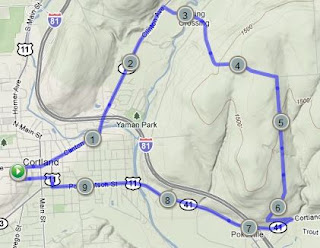
The hotel where I was staying was located right on Town Lake, which cuts through the middle of Austin and has a very popular jogging path around its entire shoreline. My plan was to follow this path for 3 miles to the Barton Creek Greenbelt, Austin's largest natural area, and then run up the first 3.5 miles of the 8-mile Barton Creek Trail. This seemed like it would make for a nice 13 mile round-trip run that would sample Austin's finest trails.
 |
| Map of my planned route (in blue) and unplanned detour (in orange). |
 |
| Austin skyline before dawn. |
Soon I came to a sign marking the start of the Barton Creek Trail, and I made my way up the increasingly rocky path as the first hints of light began to appear in the sky. The trail closely followed the creek, which was bone dry above the springs and flanked on either side by steep slopes littered with bleached white boulders. Though the urban sounds never quite disappeared, it otherwise didn't feel like I was running through the city- quite nice.
The main trail was very wide and had good footing, but in the dim light I kept accidentally veering off onto narrow, rocky side paths. Now I love me some good single track, but I wanted to finish the run before it got hellishly hot, and I didn't want to slow my pace too much. I eventually came to a wide path that crossed the creek, and remembering that I would need to make a crossing at some point, figured this was the main trail. I followed it for a while, but the trail became gradually less distinct and more rocky, eventually leaving me picking my way through a boulder field in the dense, scrubby forest. This was definitely not the main trail.
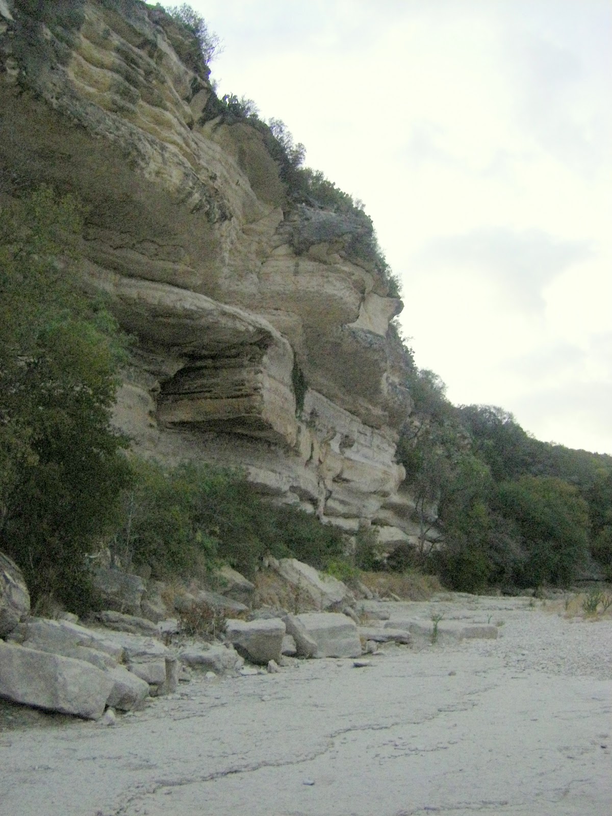 |
| Cliffs above Barton Creek. |
Eventually I came to a break in the cliffs, and I decided to climb up in search of the trail. This was no monster hill and I'm no stranger to climbing (I had just run Escarpment for Christ's sake), but it was steep and the weather was starting to get sauna-like. The sweat was pouring off me when I emerged at the top to find a lawn and some buildings, but no trail. Damn it. After some wandering and looking around, it became clear that I really was lost, and as disappointing as it was, it seemed my best option would be to abandon the trails and find my way back on roads.
 |
| Looking back across the Barton Creek Greenbelt from "The Compound" |
Luckily, the street I found was a main boulevard heading directly back into the city, and I could see the downtown skyscrapers ahead of me to confirm that I was going in the right direction. The rest of the run was pretty dismal- a long slog past strip malls and gas stations in the blazing heat- and I sweated an absurd amount. I felt a little self conscious but very relieved when I finally dragged my tired, sweat-drenched body through the hotel doors and felt a blast of frigid air. Those Texans know how to crank the AC.
 |
| Town Lake |
Monday, August 8, 2011
Weekly Summary: August 1-7
Mon and Tues: rest and recovery from Escarpment.
Wed: Wilderness-Bog Loop at Lime Hollow (~6 mi)
I felt really fantastic on this run- apparently two days was the perfect amount of rest after Escarpment. The trails at Lime Hollow were in great condition, totally dry and no overgrowth. See this previous post for a map and description of the route.
Thurs: Road run, Carr Hill loop (10 mi, 1:30)
I spontaneously decided to go for a 10 mile road run in the evening, and I wanted to run somewhere I'd never been before. This didn't leave many options, but I made a loop that went over the prominent hill across the river to the east of Cortland using Ames and Carr Hill Roads.
The first and last few miles weren't too pleasant, passing through urban and industrial areas, but the middle portion was very nice, traversing the rural countryside and rolling hills that make central New York a pretty if unspectacular place.
Fri: rest
Sat: Trail run in Morgan Hill State Forest (15 mi, 2700 ft. gain, 2:55)
Again wanting to try something new for my weekly long run, I headed up to Morgan Hill State Forest, which is a fairly large tract of land between Truxton and Fabius. The main path through this area is the Onondaga Trail, which is part of the North Country Trail as it works its way from the Finger Lakes Trail up to the Adirondacks.
My route today was a figure 8, consisting of a big loop on the Onondaga Trail and Morgan Hill/Rowley Hill Roads and a smaller loop up Fellows Hill on the Herlihy Spur Trail and Herlihy Road. Check out this page from cnyhiking.com for nice maps and descriptions of both loops. Shackham Road intersects the Onondaga Trail twice, and I aimed to park at the southern intersection. I somehow missed it and ended up at the northern one, which I didn't realize until I had been running a while and found myself nowhere near where I expected to be. Eventually I figured things out and was able to complete my planned route.
I've found that state forests in central New York are often lacking in points of interest, but Morgan Hill has several and this run hit them all- a couple nice ponds (Spruce and Shackham), a waterfall spilling off an overhanging cliff (Tinkers), a pretty little glen (Hemlock), and even an old cemetery in the middle of the woods. The scenic highlight, though, is definitely the view from the hang glider launch on Jones Hill. This is one of the outstanding views in the region, looking across Labrador Hollow, a narrow, steep-walled, 800-foot deep valley gouged out by the glaciers. Unfortunately, I encountered this magnificent viewpoint in the middle of a mad dash from a swarm of vicious deer flies. Stopping to fully enjoy the scenery was not an option, but I'll try to come back and check it out in the fall.
Sun: Road run in Cortland (3.4 mi)
Up Owego Street, across Starr Road, and down Page Green Road/Main Street.
Wednesday, August 3, 2011
Escarpment Trail Run
For me, the Escarpment Trail Run is almost the perfect race: a point to point run on 100% rocky, technical single track with zero road crossings, across a rugged mountain range with big climbs and bigger views. It's no surprise, then, that this is a race that has alternately fascinated, intimidated, and motivated me ever since I began trail running.
From years of reading and hearing about the race, the run itself and all the traditions and quirks surrounding it had taken on an almost legendary status in my mind, so it was exciting and surreal to actually participate in it: filling in my IQ score on the race application; opening the letter informing me that "do to a stroke of bad luck, your entry into the Escarpment Trail Run has been accepted;" riding the school bus from North Lake to the start; listening to founder and director Dick Vincent's pre-race instructions/comedy routine; applauding the runners going for their 100-mile shirts; seeing 10 (make that 11) time winner Ben Nephew at the starting line; and finally taking off into the woods with 200 other runners to face 30 km of beautiful and demanding trail.
Before I recount my race, here's a quick description of the course. It follows the Escarpment Trail from north to south along the Wall of Manitou, a series of peaks that makes up the sheer eastern edge of the Catskill Mountains. The trail begins with a big but gradual climb to Windham Peak, gaining 1,700 ft. in 3.4 mi. Next comes 4.6 mi. of rolling downhill, punctuated by short climbs to Burnt Knob and Acra Point, to the base of Blackhead. From there, it's a brutally steep climb of 1,100 ft. in only 0.9 mi. to Blackhead's summit, followed by a long downhill to Dutcher's North, dropping 1,400 ft. in 2.8 mi. The last major ascent, to Stoppel Point, is broken into three steep climbs separated by relatively flat sections, for a total gain of almost 1,000 ft. in 2.2 mi. Finally, there's 4.6 miles of downhill to the finish at North Lake.
I was extremely determined to avoid going out too hard, so even though the long climb up Windham was almost entirely runnable, I forced myself to walk all the steep sections. This resulted in me getting passed often early in the climb, but by plugging away at a steady pace, I was able to overtake many people higher up and reach the summit feeling very fresh. Still wanting to conserve energy, I took it fairly easy on the descent, which was a good choice because thick grass hung over the rocky trail in many places, making this the most treacherous portion of the entire course.
Other than the initial steep drop from Windham and minor climbs to Burnt Knob and Acra Point, most of the trail to the base of Blackhead was actually quite runnable. Even on the flat sections, though, the trail was relentlessly rocky, requiring constant concentration on foot placement for the entire race. Any lapse in focus, even for a few moments, would result in me bashing a rock with my toe and stumbling forward. I even fell twice, though luckily neither was too serious.
I enjoyed running on this fairly easy section but didn't open it up too much because I knew what was ahead: Blackhead. I passed through the aid station at the base of the climb and switched into power hiking mode. This served me well for about the first half of the ascent, which was certainly steep but not outrageous. Soon, though, I came to a point where I looked up briefly from the trail and saw an absolute wall of broken rock ledges and gnarled tree roots towering over me for hundreds of feet. So... this was it.
I refocused on the few feet of trail directly in front of me and slowly progressed upwards, one ledge at a time, using as tiny steps as possible. I've never worked so hard to move so slowly, but eventually the deciduous forest transitioned to red spruce and balsam fir, the slope eased up, and I emerged into the sunlight of a rock ledge with aid station workers shouting encouragement. I was on top of Blackhead and still had some life in me.
The descent from Blackhead offered similar terrain as the ascent, only in reverse. This made for some very tricky and technical running, but I took my time, picking the best lines down the steep ledges. After rapidly descending about 500 ft., the trail leveled out to allow some comfortable running. I passed a volunteer who said I was running in 23rd place, and this news gave me a shot of motivation. A top 20 finish was one of my outside goals, and I was feeling confident that I could run strong the rest of the race and maybe pass a few people. I made the final plunge down to Dutcher's Notch, passing one runner at the aid station. Two more to go!
Now came the final climb, the 3-stage push up to Stoppel Point. This was the time to cash in on the energy I had saved by running conservatively early in the race. I felt good power hiking up the first two steep sections. The pain came on the third section, put I pushed through knowing that this was the last climb of the race. I passed the wrecked airplane just off the trail, and soon I was cruising across the flat summit with nothing but downhill between me and the finish.
The climbing was over, but the difficulty wasn't, as the trail remained as rocky and technical as ever, and all that abuse to my legs started to take its toll. My pace had slowed considerably by the time I came to North Point, a rock ledge with spectacular views across the Hudson Valley and down to North Lake, the finish, which seemed almost close enough to touch. I allowed myself a few moments to take in the view, then dropped off the ledge and back into the woods- only to find I was off the trail. Unable to lift either leg high enough to step back up without cramping, I awkwardly belly flopped up onto the ledge, clambered to my feet, spotted a trail marker, and resumed my run.
After a few moments, I passed another runner coming in the opposite direction. We exchanged puzzled looks and a few confused words but both continued on, confident we were going the right way. Soon doubt started to creep in, and then I saw more runners coming towards me. I dropped an F-bomb, turned around, and powered by the biggest adrenaline rush of my life, bombed down the hill like a mad man. I quickly blew past the runner who had just passed me, letting him know "you were right."
Soon the rush tapered off, the pain returned, and I realized I had just spent most of my remaining energy. The rest of the race was a grind, dropping down ledge after ledge on beaten legs, dealing with tricky trail junctions, and passing lots of day hikers from North Lake. Finally I emerged from the woods into the finishing area, and a volunteer called out my time of 3:57:21, comfortably below my goal of four hours, though just outside the top 20.
Relaxing at the finish line and in the refreshing waters of North Lake, I relived the race and swapped trail running stories with my fellow runners, enjoying the instant camaraderie created by sharing such an amazing experience. The Escarpment Trail Run is really a unique and special race, due as much to its dedicated community of runners and volunteers as to the mountains and trail. I am very grateful to the volunteers who hauled food and drinks on their backs for hours to give me and the other runners the opportunity to run unencumbered through these incredible mountains. This race lived up to all my lofty expectations, and I have a strong feeling I'll be back.
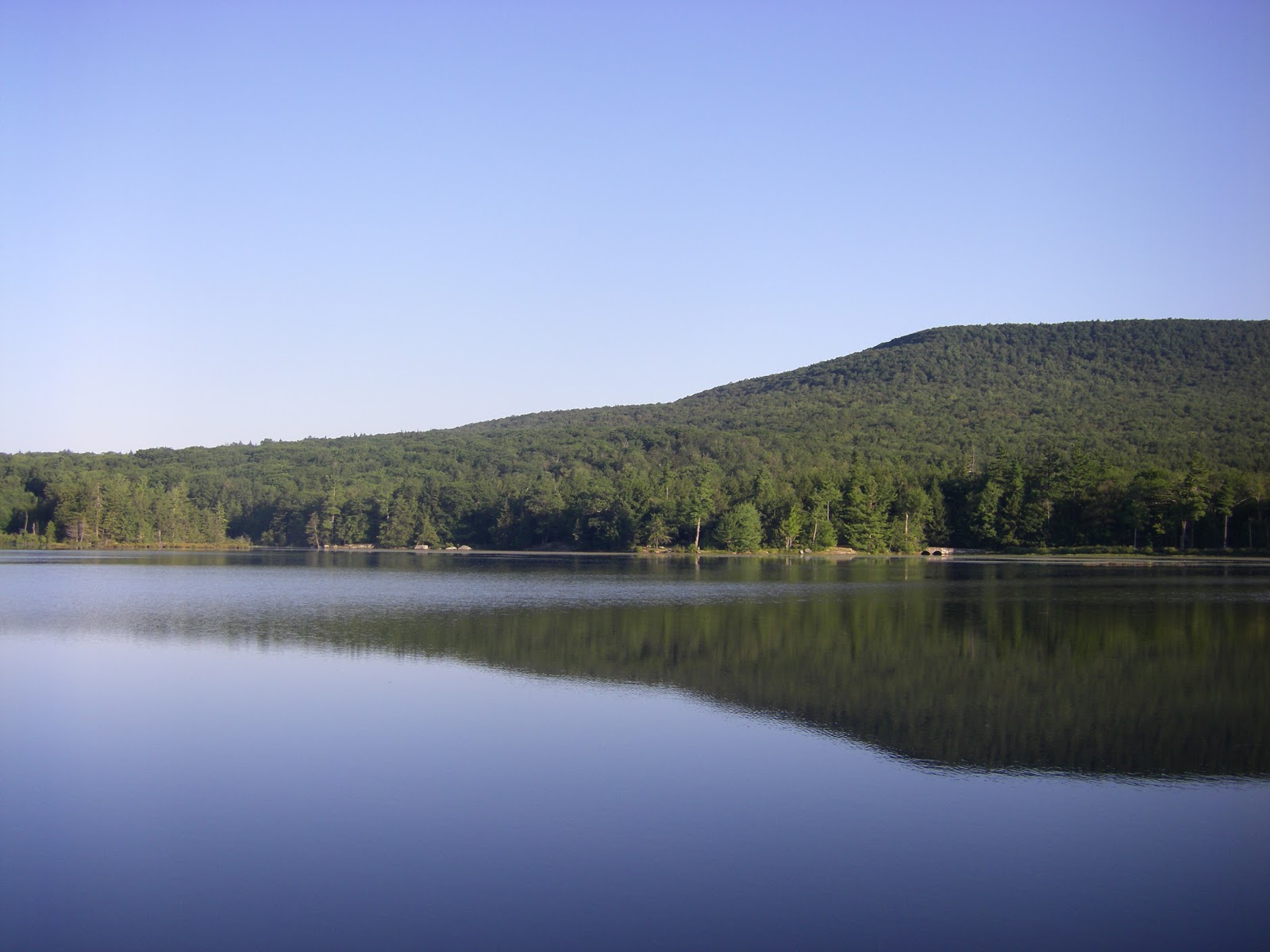 |
| Early morning view of North Mountain from the finish at North Lake |
From years of reading and hearing about the race, the run itself and all the traditions and quirks surrounding it had taken on an almost legendary status in my mind, so it was exciting and surreal to actually participate in it: filling in my IQ score on the race application; opening the letter informing me that "do to a stroke of bad luck, your entry into the Escarpment Trail Run has been accepted;" riding the school bus from North Lake to the start; listening to founder and director Dick Vincent's pre-race instructions/comedy routine; applauding the runners going for their 100-mile shirts; seeing 10 (make that 11) time winner Ben Nephew at the starting line; and finally taking off into the woods with 200 other runners to face 30 km of beautiful and demanding trail.
Before I recount my race, here's a quick description of the course. It follows the Escarpment Trail from north to south along the Wall of Manitou, a series of peaks that makes up the sheer eastern edge of the Catskill Mountains. The trail begins with a big but gradual climb to Windham Peak, gaining 1,700 ft. in 3.4 mi. Next comes 4.6 mi. of rolling downhill, punctuated by short climbs to Burnt Knob and Acra Point, to the base of Blackhead. From there, it's a brutally steep climb of 1,100 ft. in only 0.9 mi. to Blackhead's summit, followed by a long downhill to Dutcher's North, dropping 1,400 ft. in 2.8 mi. The last major ascent, to Stoppel Point, is broken into three steep climbs separated by relatively flat sections, for a total gain of almost 1,000 ft. in 2.2 mi. Finally, there's 4.6 miles of downhill to the finish at North Lake.
I was extremely determined to avoid going out too hard, so even though the long climb up Windham was almost entirely runnable, I forced myself to walk all the steep sections. This resulted in me getting passed often early in the climb, but by plugging away at a steady pace, I was able to overtake many people higher up and reach the summit feeling very fresh. Still wanting to conserve energy, I took it fairly easy on the descent, which was a good choice because thick grass hung over the rocky trail in many places, making this the most treacherous portion of the entire course.
Other than the initial steep drop from Windham and minor climbs to Burnt Knob and Acra Point, most of the trail to the base of Blackhead was actually quite runnable. Even on the flat sections, though, the trail was relentlessly rocky, requiring constant concentration on foot placement for the entire race. Any lapse in focus, even for a few moments, would result in me bashing a rock with my toe and stumbling forward. I even fell twice, though luckily neither was too serious.
I enjoyed running on this fairly easy section but didn't open it up too much because I knew what was ahead: Blackhead. I passed through the aid station at the base of the climb and switched into power hiking mode. This served me well for about the first half of the ascent, which was certainly steep but not outrageous. Soon, though, I came to a point where I looked up briefly from the trail and saw an absolute wall of broken rock ledges and gnarled tree roots towering over me for hundreds of feet. So... this was it.
I refocused on the few feet of trail directly in front of me and slowly progressed upwards, one ledge at a time, using as tiny steps as possible. I've never worked so hard to move so slowly, but eventually the deciduous forest transitioned to red spruce and balsam fir, the slope eased up, and I emerged into the sunlight of a rock ledge with aid station workers shouting encouragement. I was on top of Blackhead and still had some life in me.
The descent from Blackhead offered similar terrain as the ascent, only in reverse. This made for some very tricky and technical running, but I took my time, picking the best lines down the steep ledges. After rapidly descending about 500 ft., the trail leveled out to allow some comfortable running. I passed a volunteer who said I was running in 23rd place, and this news gave me a shot of motivation. A top 20 finish was one of my outside goals, and I was feeling confident that I could run strong the rest of the race and maybe pass a few people. I made the final plunge down to Dutcher's Notch, passing one runner at the aid station. Two more to go!
Now came the final climb, the 3-stage push up to Stoppel Point. This was the time to cash in on the energy I had saved by running conservatively early in the race. I felt good power hiking up the first two steep sections. The pain came on the third section, put I pushed through knowing that this was the last climb of the race. I passed the wrecked airplane just off the trail, and soon I was cruising across the flat summit with nothing but downhill between me and the finish.
The climbing was over, but the difficulty wasn't, as the trail remained as rocky and technical as ever, and all that abuse to my legs started to take its toll. My pace had slowed considerably by the time I came to North Point, a rock ledge with spectacular views across the Hudson Valley and down to North Lake, the finish, which seemed almost close enough to touch. I allowed myself a few moments to take in the view, then dropped off the ledge and back into the woods- only to find I was off the trail. Unable to lift either leg high enough to step back up without cramping, I awkwardly belly flopped up onto the ledge, clambered to my feet, spotted a trail marker, and resumed my run.
After a few moments, I passed another runner coming in the opposite direction. We exchanged puzzled looks and a few confused words but both continued on, confident we were going the right way. Soon doubt started to creep in, and then I saw more runners coming towards me. I dropped an F-bomb, turned around, and powered by the biggest adrenaline rush of my life, bombed down the hill like a mad man. I quickly blew past the runner who had just passed me, letting him know "you were right."
 |
| Dick Vincent told us to follow these markers. That I did, but not always in the right direction. |
Soon the rush tapered off, the pain returned, and I realized I had just spent most of my remaining energy. The rest of the race was a grind, dropping down ledge after ledge on beaten legs, dealing with tricky trail junctions, and passing lots of day hikers from North Lake. Finally I emerged from the woods into the finishing area, and a volunteer called out my time of 3:57:21, comfortably below my goal of four hours, though just outside the top 20.
Relaxing at the finish line and in the refreshing waters of North Lake, I relived the race and swapped trail running stories with my fellow runners, enjoying the instant camaraderie created by sharing such an amazing experience. The Escarpment Trail Run is really a unique and special race, due as much to its dedicated community of runners and volunteers as to the mountains and trail. I am very grateful to the volunteers who hauled food and drinks on their backs for hours to give me and the other runners the opportunity to run unencumbered through these incredible mountains. This race lived up to all my lofty expectations, and I have a strong feeling I'll be back.
Subscribe to:
Posts (Atom)