This week was broken up by a trip to Austin, Texas, for a conference, but I actually got in quite a bit of good running.
Mon: Cortland road run (3.4 mi)
An easy run around town before catching my flight to Austin.
Tues: rest/acclimation to crazy Texas heat
Wed: Trail/road run/getting lost in Austin (~10 mi)
This was an interesting adventure. Check out this post for a full description.
Thurs: rest/flying back to nice, cool central New York
Fri: Trail run at Lime Hollow (~6.5 mi)
Ah, it's nice to be back in sub-100 degree temperatures. This was a beautiful day and I had a great run on an extended version of the Bog-Wilderness Loop.
Sat: Finger Lakes Trail in Hammond Hill and Robinson Hollow S.F. (15.2 mi, 2740 ft gain)
I drove out to Dryden to check out a new segment of the Finger Lakes Trail that crosses two state forests (Hammond Hill and Robinson Hollow) and two counties (Tompkins and Tioga). Check out this page from cnyhiking.com for a map.
The run began with a 700+ foot climb from NY Route 38 to the microwave tower on Hammond Hill. For the first part of the climb, the FLT follows Star Stanton Road, which is initially paved but soon turns to dirt and becomes increasingly washed out- don't try to drive here. At the top of the plateau, the trail turns into single track and for the next couple miles follows the course of Thom Bugliosi Trail Runs, a great local early-season race that I've run the last couple years. You'll also see on this section some yellow and red disks marking ski trails, part of Hammond Hill's fantastic trail network for cross-country skiing. These hills seem to hold onto snow really well, making for consistently good conditions and a long season. Here's hoping for another snowy winter!
After reaching the microwave tower at a little over 2000 ft, the trail descends to Harford-Slaterville Road, enters Robinson Hollow State Forest, and climbs another hill. This section of trail was a bit overgrown and, at least on this morning, crossed by tons of spider webs. As the first runner of the day to pass through, I was rewarded by taking many of these in the face. The section on top of the hill and descending the other side was much better, passing through some open forest and then following a nice, though currently dry, little stream. After a short, steep climb from the stream, the trail drops down into Robinson Hollow, my turnaround for the day.
Sun: Blue Creek loop (6 mi)
A nice, moderate road run in Cortland. Check out this previous post for a map.

Tuesday, August 16, 2011
Saturday, August 13, 2011
Lost in Texas
When I think of Texas, I think of cowboys and guns and George W. Bush, not trail running. So when I registered for a conference in the capital of the Lone Star State, I wasn't too excited about the trail running possibilities, especially as the event drew nearer and the weather forecast called for temperatures in the mid 100's. But after digging around on the internet, I found that Austin is actually something of an urban trail running hot spot, with an impressive selection of trails right in the city. So I decided to get up very early one day to do some exploring.
The hotel where I was staying was located right on Town Lake, which cuts through the middle of Austin and has a very popular jogging path around its entire shoreline. My plan was to follow this path for 3 miles to the Barton Creek Greenbelt, Austin's largest natural area, and then run up the first 3.5 miles of the 8-mile Barton Creek Trail. This seemed like it would make for a nice 13 mile round-trip run that would sample Austin's finest trails.
At 5:30, I was on the trail and the weather was already uncomfortably if not miserably hot and humid. The sun was still a long way from coming up, but the city lights provided enough light to make out the trail and jog at a steady pace. Soon I passed under the Congress Avenue Bridge, home of over 1 million Mexican free-tailed bats. They emerge as a group each day at dusk to find their dinner, and watching them from the bridge was pretty awesome. It was a little unnerving to run beneath their roost at night, but I hardly even noticed them besides their squeaking.
After crossing the lake on a pedestrian bridge, I took a left-hand turn and started following Barton Creek. This creek is fed by some large springs that pump out 68 degree water year round, and the people of Austin wisely built a huge pool to take advantage of this. There were already quite a few people there swimming laps when I ran by before dawn, and I figured I might want to stop for a swim on the way back. Unfortunately, I would not pass this way again.
Soon I came to a sign marking the start of the Barton Creek Trail, and I made my way up the increasingly rocky path as the first hints of light began to appear in the sky. The trail closely followed the creek, which was bone dry above the springs and flanked on either side by steep slopes littered with bleached white boulders. Though the urban sounds never quite disappeared, it otherwise didn't feel like I was running through the city- quite nice.
The main trail was very wide and had good footing, but in the dim light I kept accidentally veering off onto narrow, rocky side paths. Now I love me some good single track, but I wanted to finish the run before it got hellishly hot, and I didn't want to slow my pace too much. I eventually came to a wide path that crossed the creek, and remembering that I would need to make a crossing at some point, figured this was the main trail. I followed it for a while, but the trail became gradually less distinct and more rocky, eventually leaving me picking my way through a boulder field in the dense, scrubby forest. This was definitely not the main trail.
At this point, it seemed my best option was to just run up the dry creek bed, so that's what I did. I actually enjoyed this quite a bit at first. The relatively flat bedrock provided good footing, and the large boulders in the creek and impressive cliffs on the left bank provided interesting scenery. However, the bedrock soon gave way to stretches of loose gravel and jumbled boulders, and the going became really tough. This was more than I had bargained for, and at this point I just wanted to find the real trail, which I thought was to my left, on top of the cliff band.
Eventually I came to a break in the cliffs, and I decided to climb up in search of the trail. This was no monster hill and I'm no stranger to climbing (I had just run Escarpment for Christ's sake), but it was steep and the weather was starting to get sauna-like. The sweat was pouring off me when I emerged at the top to find a lawn and some buildings, but no trail. Damn it. After some wandering and looking around, it became clear that I really was lost, and as disappointing as it was, it seemed my best option would be to abandon the trails and find my way back on roads.
First, though, I would have to find a road. I thought this would be easy enough, but soon it became clear that I wasn't in somebody's yard but some kind of weird compound that vaguely reminded me of the Dharma Initiative from Lost- kind of creepy. I eventually found a driveway that led to a busy street, and I hopped a gate and booked out, happy to have escaped the compound without having been shot or abducted.
Luckily, the street I found was a main boulevard heading directly back into the city, and I could see the downtown skyscrapers ahead of me to confirm that I was going in the right direction. The rest of the run was pretty dismal- a long slog past strip malls and gas stations in the blazing heat- and I sweated an absurd amount. I felt a little self conscious but very relieved when I finally dragged my tired, sweat-drenched body through the hotel doors and felt a blast of frigid air. Those Texans know how to crank the AC.
So in the end I learned something from this run: don't go for a run at night in a strange place without a map, especially when the weather forecast is for 105-degree heat and 80% humidity. I'm sure Texas has some great things going for it, but I think I'm all set after this trip.
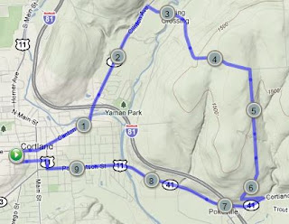
The hotel where I was staying was located right on Town Lake, which cuts through the middle of Austin and has a very popular jogging path around its entire shoreline. My plan was to follow this path for 3 miles to the Barton Creek Greenbelt, Austin's largest natural area, and then run up the first 3.5 miles of the 8-mile Barton Creek Trail. This seemed like it would make for a nice 13 mile round-trip run that would sample Austin's finest trails.
 |
| Map of my planned route (in blue) and unplanned detour (in orange). |
 |
| Austin skyline before dawn. |
Soon I came to a sign marking the start of the Barton Creek Trail, and I made my way up the increasingly rocky path as the first hints of light began to appear in the sky. The trail closely followed the creek, which was bone dry above the springs and flanked on either side by steep slopes littered with bleached white boulders. Though the urban sounds never quite disappeared, it otherwise didn't feel like I was running through the city- quite nice.
The main trail was very wide and had good footing, but in the dim light I kept accidentally veering off onto narrow, rocky side paths. Now I love me some good single track, but I wanted to finish the run before it got hellishly hot, and I didn't want to slow my pace too much. I eventually came to a wide path that crossed the creek, and remembering that I would need to make a crossing at some point, figured this was the main trail. I followed it for a while, but the trail became gradually less distinct and more rocky, eventually leaving me picking my way through a boulder field in the dense, scrubby forest. This was definitely not the main trail.
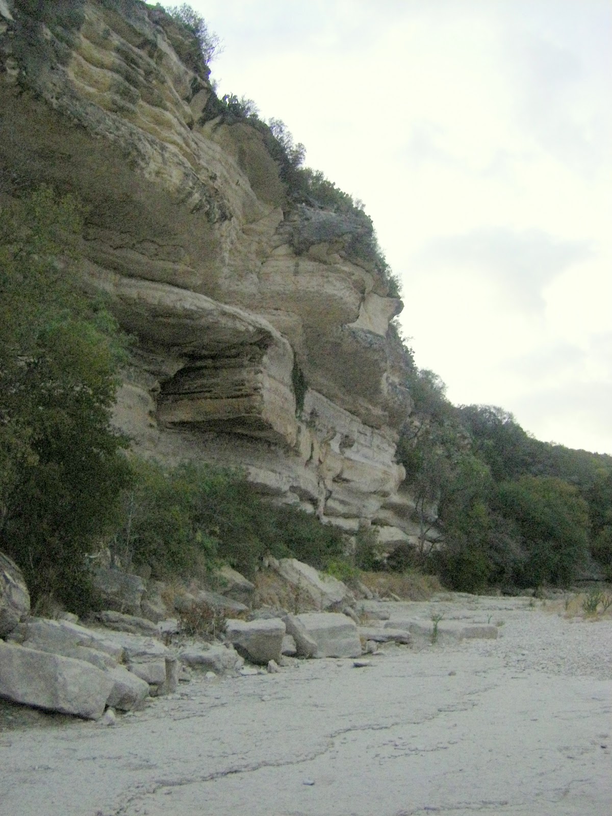 |
| Cliffs above Barton Creek. |
Eventually I came to a break in the cliffs, and I decided to climb up in search of the trail. This was no monster hill and I'm no stranger to climbing (I had just run Escarpment for Christ's sake), but it was steep and the weather was starting to get sauna-like. The sweat was pouring off me when I emerged at the top to find a lawn and some buildings, but no trail. Damn it. After some wandering and looking around, it became clear that I really was lost, and as disappointing as it was, it seemed my best option would be to abandon the trails and find my way back on roads.
 |
| Looking back across the Barton Creek Greenbelt from "The Compound" |
Luckily, the street I found was a main boulevard heading directly back into the city, and I could see the downtown skyscrapers ahead of me to confirm that I was going in the right direction. The rest of the run was pretty dismal- a long slog past strip malls and gas stations in the blazing heat- and I sweated an absurd amount. I felt a little self conscious but very relieved when I finally dragged my tired, sweat-drenched body through the hotel doors and felt a blast of frigid air. Those Texans know how to crank the AC.
 |
| Town Lake |
Monday, August 8, 2011
Weekly Summary: August 1-7
Mon and Tues: rest and recovery from Escarpment.
Wed: Wilderness-Bog Loop at Lime Hollow (~6 mi)
I felt really fantastic on this run- apparently two days was the perfect amount of rest after Escarpment. The trails at Lime Hollow were in great condition, totally dry and no overgrowth. See this previous post for a map and description of the route.
Thurs: Road run, Carr Hill loop (10 mi, 1:30)
I spontaneously decided to go for a 10 mile road run in the evening, and I wanted to run somewhere I'd never been before. This didn't leave many options, but I made a loop that went over the prominent hill across the river to the east of Cortland using Ames and Carr Hill Roads.
The first and last few miles weren't too pleasant, passing through urban and industrial areas, but the middle portion was very nice, traversing the rural countryside and rolling hills that make central New York a pretty if unspectacular place.
Fri: rest
Sat: Trail run in Morgan Hill State Forest (15 mi, 2700 ft. gain, 2:55)
Again wanting to try something new for my weekly long run, I headed up to Morgan Hill State Forest, which is a fairly large tract of land between Truxton and Fabius. The main path through this area is the Onondaga Trail, which is part of the North Country Trail as it works its way from the Finger Lakes Trail up to the Adirondacks.
My route today was a figure 8, consisting of a big loop on the Onondaga Trail and Morgan Hill/Rowley Hill Roads and a smaller loop up Fellows Hill on the Herlihy Spur Trail and Herlihy Road. Check out this page from cnyhiking.com for nice maps and descriptions of both loops. Shackham Road intersects the Onondaga Trail twice, and I aimed to park at the southern intersection. I somehow missed it and ended up at the northern one, which I didn't realize until I had been running a while and found myself nowhere near where I expected to be. Eventually I figured things out and was able to complete my planned route.
I've found that state forests in central New York are often lacking in points of interest, but Morgan Hill has several and this run hit them all- a couple nice ponds (Spruce and Shackham), a waterfall spilling off an overhanging cliff (Tinkers), a pretty little glen (Hemlock), and even an old cemetery in the middle of the woods. The scenic highlight, though, is definitely the view from the hang glider launch on Jones Hill. This is one of the outstanding views in the region, looking across Labrador Hollow, a narrow, steep-walled, 800-foot deep valley gouged out by the glaciers. Unfortunately, I encountered this magnificent viewpoint in the middle of a mad dash from a swarm of vicious deer flies. Stopping to fully enjoy the scenery was not an option, but I'll try to come back and check it out in the fall.
Sun: Road run in Cortland (3.4 mi)
Up Owego Street, across Starr Road, and down Page Green Road/Main Street.
Wednesday, August 3, 2011
Escarpment Trail Run
For me, the Escarpment Trail Run is almost the perfect race: a point to point run on 100% rocky, technical single track with zero road crossings, across a rugged mountain range with big climbs and bigger views. It's no surprise, then, that this is a race that has alternately fascinated, intimidated, and motivated me ever since I began trail running.
From years of reading and hearing about the race, the run itself and all the traditions and quirks surrounding it had taken on an almost legendary status in my mind, so it was exciting and surreal to actually participate in it: filling in my IQ score on the race application; opening the letter informing me that "do to a stroke of bad luck, your entry into the Escarpment Trail Run has been accepted;" riding the school bus from North Lake to the start; listening to founder and director Dick Vincent's pre-race instructions/comedy routine; applauding the runners going for their 100-mile shirts; seeing 10 (make that 11) time winner Ben Nephew at the starting line; and finally taking off into the woods with 200 other runners to face 30 km of beautiful and demanding trail.
Before I recount my race, here's a quick description of the course. It follows the Escarpment Trail from north to south along the Wall of Manitou, a series of peaks that makes up the sheer eastern edge of the Catskill Mountains. The trail begins with a big but gradual climb to Windham Peak, gaining 1,700 ft. in 3.4 mi. Next comes 4.6 mi. of rolling downhill, punctuated by short climbs to Burnt Knob and Acra Point, to the base of Blackhead. From there, it's a brutally steep climb of 1,100 ft. in only 0.9 mi. to Blackhead's summit, followed by a long downhill to Dutcher's North, dropping 1,400 ft. in 2.8 mi. The last major ascent, to Stoppel Point, is broken into three steep climbs separated by relatively flat sections, for a total gain of almost 1,000 ft. in 2.2 mi. Finally, there's 4.6 miles of downhill to the finish at North Lake.
I was extremely determined to avoid going out too hard, so even though the long climb up Windham was almost entirely runnable, I forced myself to walk all the steep sections. This resulted in me getting passed often early in the climb, but by plugging away at a steady pace, I was able to overtake many people higher up and reach the summit feeling very fresh. Still wanting to conserve energy, I took it fairly easy on the descent, which was a good choice because thick grass hung over the rocky trail in many places, making this the most treacherous portion of the entire course.
Other than the initial steep drop from Windham and minor climbs to Burnt Knob and Acra Point, most of the trail to the base of Blackhead was actually quite runnable. Even on the flat sections, though, the trail was relentlessly rocky, requiring constant concentration on foot placement for the entire race. Any lapse in focus, even for a few moments, would result in me bashing a rock with my toe and stumbling forward. I even fell twice, though luckily neither was too serious.
I enjoyed running on this fairly easy section but didn't open it up too much because I knew what was ahead: Blackhead. I passed through the aid station at the base of the climb and switched into power hiking mode. This served me well for about the first half of the ascent, which was certainly steep but not outrageous. Soon, though, I came to a point where I looked up briefly from the trail and saw an absolute wall of broken rock ledges and gnarled tree roots towering over me for hundreds of feet. So... this was it.
I refocused on the few feet of trail directly in front of me and slowly progressed upwards, one ledge at a time, using as tiny steps as possible. I've never worked so hard to move so slowly, but eventually the deciduous forest transitioned to red spruce and balsam fir, the slope eased up, and I emerged into the sunlight of a rock ledge with aid station workers shouting encouragement. I was on top of Blackhead and still had some life in me.
The descent from Blackhead offered similar terrain as the ascent, only in reverse. This made for some very tricky and technical running, but I took my time, picking the best lines down the steep ledges. After rapidly descending about 500 ft., the trail leveled out to allow some comfortable running. I passed a volunteer who said I was running in 23rd place, and this news gave me a shot of motivation. A top 20 finish was one of my outside goals, and I was feeling confident that I could run strong the rest of the race and maybe pass a few people. I made the final plunge down to Dutcher's Notch, passing one runner at the aid station. Two more to go!
Now came the final climb, the 3-stage push up to Stoppel Point. This was the time to cash in on the energy I had saved by running conservatively early in the race. I felt good power hiking up the first two steep sections. The pain came on the third section, put I pushed through knowing that this was the last climb of the race. I passed the wrecked airplane just off the trail, and soon I was cruising across the flat summit with nothing but downhill between me and the finish.
The climbing was over, but the difficulty wasn't, as the trail remained as rocky and technical as ever, and all that abuse to my legs started to take its toll. My pace had slowed considerably by the time I came to North Point, a rock ledge with spectacular views across the Hudson Valley and down to North Lake, the finish, which seemed almost close enough to touch. I allowed myself a few moments to take in the view, then dropped off the ledge and back into the woods- only to find I was off the trail. Unable to lift either leg high enough to step back up without cramping, I awkwardly belly flopped up onto the ledge, clambered to my feet, spotted a trail marker, and resumed my run.
After a few moments, I passed another runner coming in the opposite direction. We exchanged puzzled looks and a few confused words but both continued on, confident we were going the right way. Soon doubt started to creep in, and then I saw more runners coming towards me. I dropped an F-bomb, turned around, and powered by the biggest adrenaline rush of my life, bombed down the hill like a mad man. I quickly blew past the runner who had just passed me, letting him know "you were right."
Soon the rush tapered off, the pain returned, and I realized I had just spent most of my remaining energy. The rest of the race was a grind, dropping down ledge after ledge on beaten legs, dealing with tricky trail junctions, and passing lots of day hikers from North Lake. Finally I emerged from the woods into the finishing area, and a volunteer called out my time of 3:57:21, comfortably below my goal of four hours, though just outside the top 20.
Relaxing at the finish line and in the refreshing waters of North Lake, I relived the race and swapped trail running stories with my fellow runners, enjoying the instant camaraderie created by sharing such an amazing experience. The Escarpment Trail Run is really a unique and special race, due as much to its dedicated community of runners and volunteers as to the mountains and trail. I am very grateful to the volunteers who hauled food and drinks on their backs for hours to give me and the other runners the opportunity to run unencumbered through these incredible mountains. This race lived up to all my lofty expectations, and I have a strong feeling I'll be back.
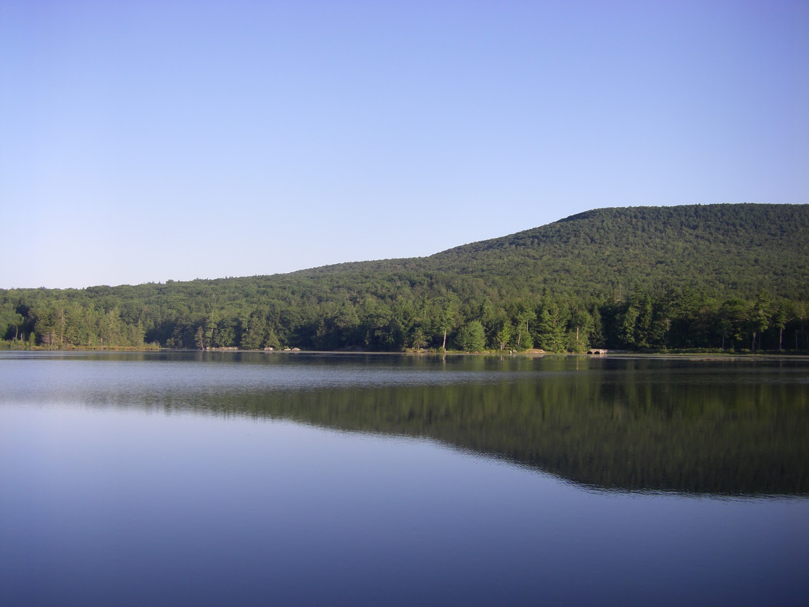 |
| Early morning view of North Mountain from the finish at North Lake |
From years of reading and hearing about the race, the run itself and all the traditions and quirks surrounding it had taken on an almost legendary status in my mind, so it was exciting and surreal to actually participate in it: filling in my IQ score on the race application; opening the letter informing me that "do to a stroke of bad luck, your entry into the Escarpment Trail Run has been accepted;" riding the school bus from North Lake to the start; listening to founder and director Dick Vincent's pre-race instructions/comedy routine; applauding the runners going for their 100-mile shirts; seeing 10 (make that 11) time winner Ben Nephew at the starting line; and finally taking off into the woods with 200 other runners to face 30 km of beautiful and demanding trail.
Before I recount my race, here's a quick description of the course. It follows the Escarpment Trail from north to south along the Wall of Manitou, a series of peaks that makes up the sheer eastern edge of the Catskill Mountains. The trail begins with a big but gradual climb to Windham Peak, gaining 1,700 ft. in 3.4 mi. Next comes 4.6 mi. of rolling downhill, punctuated by short climbs to Burnt Knob and Acra Point, to the base of Blackhead. From there, it's a brutally steep climb of 1,100 ft. in only 0.9 mi. to Blackhead's summit, followed by a long downhill to Dutcher's North, dropping 1,400 ft. in 2.8 mi. The last major ascent, to Stoppel Point, is broken into three steep climbs separated by relatively flat sections, for a total gain of almost 1,000 ft. in 2.2 mi. Finally, there's 4.6 miles of downhill to the finish at North Lake.
I was extremely determined to avoid going out too hard, so even though the long climb up Windham was almost entirely runnable, I forced myself to walk all the steep sections. This resulted in me getting passed often early in the climb, but by plugging away at a steady pace, I was able to overtake many people higher up and reach the summit feeling very fresh. Still wanting to conserve energy, I took it fairly easy on the descent, which was a good choice because thick grass hung over the rocky trail in many places, making this the most treacherous portion of the entire course.
Other than the initial steep drop from Windham and minor climbs to Burnt Knob and Acra Point, most of the trail to the base of Blackhead was actually quite runnable. Even on the flat sections, though, the trail was relentlessly rocky, requiring constant concentration on foot placement for the entire race. Any lapse in focus, even for a few moments, would result in me bashing a rock with my toe and stumbling forward. I even fell twice, though luckily neither was too serious.
I enjoyed running on this fairly easy section but didn't open it up too much because I knew what was ahead: Blackhead. I passed through the aid station at the base of the climb and switched into power hiking mode. This served me well for about the first half of the ascent, which was certainly steep but not outrageous. Soon, though, I came to a point where I looked up briefly from the trail and saw an absolute wall of broken rock ledges and gnarled tree roots towering over me for hundreds of feet. So... this was it.
I refocused on the few feet of trail directly in front of me and slowly progressed upwards, one ledge at a time, using as tiny steps as possible. I've never worked so hard to move so slowly, but eventually the deciduous forest transitioned to red spruce and balsam fir, the slope eased up, and I emerged into the sunlight of a rock ledge with aid station workers shouting encouragement. I was on top of Blackhead and still had some life in me.
The descent from Blackhead offered similar terrain as the ascent, only in reverse. This made for some very tricky and technical running, but I took my time, picking the best lines down the steep ledges. After rapidly descending about 500 ft., the trail leveled out to allow some comfortable running. I passed a volunteer who said I was running in 23rd place, and this news gave me a shot of motivation. A top 20 finish was one of my outside goals, and I was feeling confident that I could run strong the rest of the race and maybe pass a few people. I made the final plunge down to Dutcher's Notch, passing one runner at the aid station. Two more to go!
Now came the final climb, the 3-stage push up to Stoppel Point. This was the time to cash in on the energy I had saved by running conservatively early in the race. I felt good power hiking up the first two steep sections. The pain came on the third section, put I pushed through knowing that this was the last climb of the race. I passed the wrecked airplane just off the trail, and soon I was cruising across the flat summit with nothing but downhill between me and the finish.
The climbing was over, but the difficulty wasn't, as the trail remained as rocky and technical as ever, and all that abuse to my legs started to take its toll. My pace had slowed considerably by the time I came to North Point, a rock ledge with spectacular views across the Hudson Valley and down to North Lake, the finish, which seemed almost close enough to touch. I allowed myself a few moments to take in the view, then dropped off the ledge and back into the woods- only to find I was off the trail. Unable to lift either leg high enough to step back up without cramping, I awkwardly belly flopped up onto the ledge, clambered to my feet, spotted a trail marker, and resumed my run.
After a few moments, I passed another runner coming in the opposite direction. We exchanged puzzled looks and a few confused words but both continued on, confident we were going the right way. Soon doubt started to creep in, and then I saw more runners coming towards me. I dropped an F-bomb, turned around, and powered by the biggest adrenaline rush of my life, bombed down the hill like a mad man. I quickly blew past the runner who had just passed me, letting him know "you were right."
 |
| Dick Vincent told us to follow these markers. That I did, but not always in the right direction. |
Soon the rush tapered off, the pain returned, and I realized I had just spent most of my remaining energy. The rest of the race was a grind, dropping down ledge after ledge on beaten legs, dealing with tricky trail junctions, and passing lots of day hikers from North Lake. Finally I emerged from the woods into the finishing area, and a volunteer called out my time of 3:57:21, comfortably below my goal of four hours, though just outside the top 20.
Relaxing at the finish line and in the refreshing waters of North Lake, I relived the race and swapped trail running stories with my fellow runners, enjoying the instant camaraderie created by sharing such an amazing experience. The Escarpment Trail Run is really a unique and special race, due as much to its dedicated community of runners and volunteers as to the mountains and trail. I am very grateful to the volunteers who hauled food and drinks on their backs for hours to give me and the other runners the opportunity to run unencumbered through these incredible mountains. This race lived up to all my lofty expectations, and I have a strong feeling I'll be back.
Tuesday, July 26, 2011
Trip Report: Tioughnioga River by kayak and tube
Cortland happens to have a nice little river, the Tioughnioga, flowing past it, and I've been meaning to check it out by kayak ever since I've lived here. With the temperatures pushing into the upper 90's and my brother, Johnny, in town with his kayak, this seemed like a good day for a relaxing trip down the river. We wanted my wife, Lindsay, to come also but were one boat short. We decided to fix this by renting a tube and taking turns lazily kayaking and even more lazily floating, with the main goal of cooling off in the river.
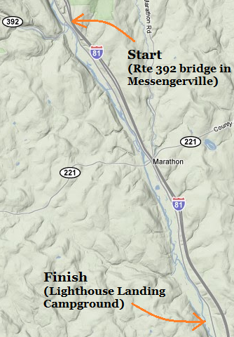
I planned to put in at the Rte. 392 bridge in Messengerville and take out at Lighthouse Landing, a private campground south of Marathon where we could rent a tube. I figured the distance would be a leisurely 7 miles, but this turned out to be an underestimate; the people at Lighthouse Landing, shocked when they heard our plan, told us the distance was more like 11-12 miles and it would take at least 8 hours to cover by tube. After some deliberation, we decided to go for it anyway, figuring that by towing the tube behind the kayaks we could make decent time.
Soon I was effortlessly gliding through the water in the tube, my wife providing the propulsion. After a bit of experimenting with attaching the tube to the kayaks, we found that tying it close behind one kayak was generally best. Pulling the tube was easier than expected for the most part, as long as there was some current to help, and it was even a fun challenge to navigate the kayak/tube combo through the riffles and sharp bends. Of course, hauling my brother through long, flat pools was not so fun, but these were relatively few and far between.
This section of river flows through an area that is far from wilderness, but it still had a nice, natural feel most of the time. I liked the stretch from Messengerville to Marathon best. With Route 11 staying far from the river, the shorelines were populated by big sycamore trees and lots of wildflowers, and the river alternated between short pools and fun little rapids where the water curved around a series of small islands. Once we came to Marathon, roads and buildings started to approach the river more, and the ratio of pools to riffles increased, but it was still a very nice paddle.
Though it was hot in the kayaks, especially when on pulling duty, we made sure to spend lots of time in the water. I even got out of the tube and swam downriver for several hundred yards at one point. It was very refreshing. Within site of the takeout, we found an excellent place to stop, on an island beside a narrow, swift chute in the river, and we took turns floating down briskly on our backs. Thoroughly cooled off, we paddled the last bit to Lighthouse Landing, finishing in just 4 1/2 hours.
This was a really fun trip, and it makes me wonder why it took me so long to get out on the river. I definitely would like to paddle more sections of the Tioughnioga before this winter, and I may even try to eventually cover the whole thing, from Cuyler to Chenango Forks.
 |
| Our route |
Soon I was effortlessly gliding through the water in the tube, my wife providing the propulsion. After a bit of experimenting with attaching the tube to the kayaks, we found that tying it close behind one kayak was generally best. Pulling the tube was easier than expected for the most part, as long as there was some current to help, and it was even a fun challenge to navigate the kayak/tube combo through the riffles and sharp bends. Of course, hauling my brother through long, flat pools was not so fun, but these were relatively few and far between.
This section of river flows through an area that is far from wilderness, but it still had a nice, natural feel most of the time. I liked the stretch from Messengerville to Marathon best. With Route 11 staying far from the river, the shorelines were populated by big sycamore trees and lots of wildflowers, and the river alternated between short pools and fun little rapids where the water curved around a series of small islands. Once we came to Marathon, roads and buildings started to approach the river more, and the ratio of pools to riffles increased, but it was still a very nice paddle.
Though it was hot in the kayaks, especially when on pulling duty, we made sure to spend lots of time in the water. I even got out of the tube and swam downriver for several hundred yards at one point. It was very refreshing. Within site of the takeout, we found an excellent place to stop, on an island beside a narrow, swift chute in the river, and we took turns floating down briskly on our backs. Thoroughly cooled off, we paddled the last bit to Lighthouse Landing, finishing in just 4 1/2 hours.
This was a really fun trip, and it makes me wonder why it took me so long to get out on the river. I definitely would like to paddle more sections of the Tioughnioga before this winter, and I may even try to eventually cover the whole thing, from Cuyler to Chenango Forks.
Monday, July 25, 2011
Weekly Summary: July 18-24
Mon: rest
Tues: 2-mile run on track (4 mi total)
The most terrifying part of the General McLane High School soccer tryouts was the 2-mile run, which prospective players were supposed to complete in under 12 minutes. I never quite made it (though it wasn't a hard cutoff, so I did always make the team), but I decided to give it another shot almost 9 years after my last attempt. I jogged down to the track at SUNY Cortland, ran hard for 2 miles in finished in 11:48. Sweet redemption.
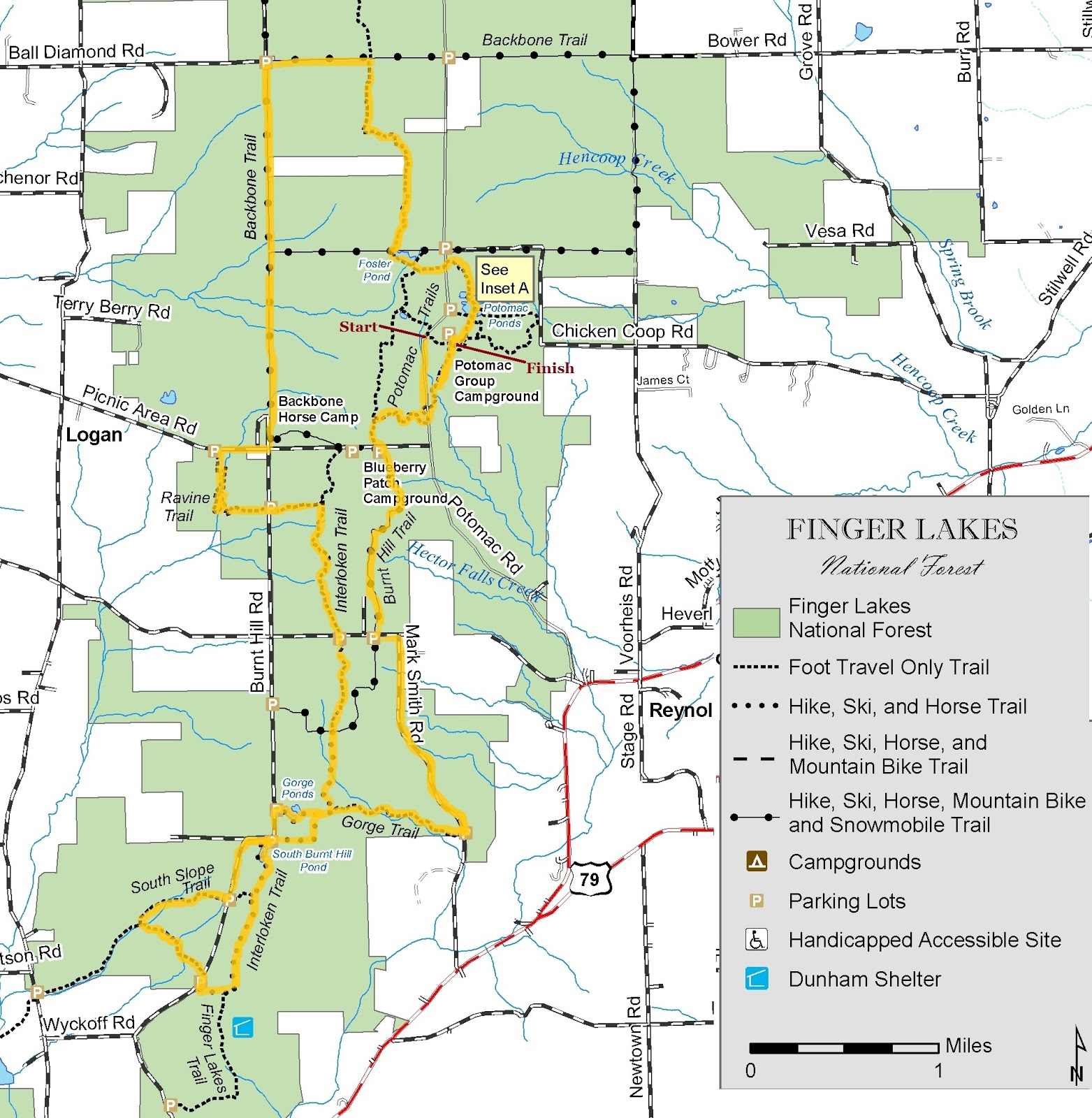
Wed: Trail Run at Green Lakes State Park (1:10)
Green Lakes is a very popular park just outside of Syracuse with trails that come in three flavors: flat, often crowded paths around the lakes, shady dirt trails through mature forest, and rolling grass trails through a large area of fields. This run sampled all three.
I parked at the end of Aladdin Drive, which is in a residential neighborhood just outside the southwest corner of the park, and ran on unmarked but well-defined paths to the Farmers Hill Trail, which runs around a very large, open field. Next I turned right on the Hernia Hill Bypass, which drops steeply into the woods, and ran through an impressive stand of old growth forest on the way to Round Lake.
Round and Green Lakes are the highlights of the park; in addition to being very scenic, they are extremely interesting in terms of their biology, geology, and chemistry. I ran a full loop around both lakes, giving me a chance to enjoy their calm, clear, and green-tinted waters. After the circuit of the lakes, I headed back up the hill, through the forests and fields, and down to my car, completing a very nice run before the day's sweltering heat set it.
Thurs and Fri: rest
Tweaked left foot + 100 degree heat = first two day break in a very long time.
Sat-AM: Trail run in Tuller Hill State Forest (11.7 mi, ~2100 ft gain, 2:10)
Unlike the convoluted routes I have been putting together for my recent long trail runs, this run was pretty straightforward: an out-and-back on the Tuller Hill section of the Finger Lakes Trail.
Parking at the intersection of Stafford and West River Roads, I started with a short run down the latter before turning into the woods and beginning the climb up Snyder Hill. This is one of the bigger climbs in the area (almost 800 ft), but it is rarely steep and is interspersed with level and even slightly downhill portions. The first segment runs along the edge of a fairly deep ravine, including an interesting promontory that drops away steeply on three sides. After topping out, the trail drops down a little and traverses the side of the hill for a while before descending to Woodchuck Hollow.
The Woodchuck Hollow section is a great piece of trail, paralleling a nice creek and dipping in and out of numerous side gullies. The footing is very tricky in places, with lots of large roots, rocks, steep drops, and sharp turns. After a little over a mile of this, the trail climbs gradually out of the hollow, then makes a short descent to Carson Road, at which point I turned around and did the whole thing in reverse.
Although I kept a decent pace throughout, this was far from my best run, primarily due to some pain in my left foot, especially on climbs and sections with uneven footing. Unfortunately, that describes pretty much all of the Escarpment Trail Run, which I'm doing next weekend. Hopefully, with some rest this week the foot issue will resolve and I'll be able to run the race at full strength.
Sat-PM: Kayaking/tubing on Tioughnioga River (~11 mi, 4:30)
Though I can't recommend pulling an inner tube behind a kayak for this distance, this was still a very fun trip. Check out my trip report.
Tues: 2-mile run on track (4 mi total)
The most terrifying part of the General McLane High School soccer tryouts was the 2-mile run, which prospective players were supposed to complete in under 12 minutes. I never quite made it (though it wasn't a hard cutoff, so I did always make the team), but I decided to give it another shot almost 9 years after my last attempt. I jogged down to the track at SUNY Cortland, ran hard for 2 miles in finished in 11:48. Sweet redemption.
Wed: Trail Run at Green Lakes State Park (1:10)
Green Lakes is a very popular park just outside of Syracuse with trails that come in three flavors: flat, often crowded paths around the lakes, shady dirt trails through mature forest, and rolling grass trails through a large area of fields. This run sampled all three.
 |
| Green Lakes trail map with my route highlighted |
I parked at the end of Aladdin Drive, which is in a residential neighborhood just outside the southwest corner of the park, and ran on unmarked but well-defined paths to the Farmers Hill Trail, which runs around a very large, open field. Next I turned right on the Hernia Hill Bypass, which drops steeply into the woods, and ran through an impressive stand of old growth forest on the way to Round Lake.
Round and Green Lakes are the highlights of the park; in addition to being very scenic, they are extremely interesting in terms of their biology, geology, and chemistry. I ran a full loop around both lakes, giving me a chance to enjoy their calm, clear, and green-tinted waters. After the circuit of the lakes, I headed back up the hill, through the forests and fields, and down to my car, completing a very nice run before the day's sweltering heat set it.
Thurs and Fri: rest
Tweaked left foot + 100 degree heat = first two day break in a very long time.
Sat-AM: Trail run in Tuller Hill State Forest (11.7 mi, ~2100 ft gain, 2:10)
Unlike the convoluted routes I have been putting together for my recent long trail runs, this run was pretty straightforward: an out-and-back on the Tuller Hill section of the Finger Lakes Trail.
Parking at the intersection of Stafford and West River Roads, I started with a short run down the latter before turning into the woods and beginning the climb up Snyder Hill. This is one of the bigger climbs in the area (almost 800 ft), but it is rarely steep and is interspersed with level and even slightly downhill portions. The first segment runs along the edge of a fairly deep ravine, including an interesting promontory that drops away steeply on three sides. After topping out, the trail drops down a little and traverses the side of the hill for a while before descending to Woodchuck Hollow.
The Woodchuck Hollow section is a great piece of trail, paralleling a nice creek and dipping in and out of numerous side gullies. The footing is very tricky in places, with lots of large roots, rocks, steep drops, and sharp turns. After a little over a mile of this, the trail climbs gradually out of the hollow, then makes a short descent to Carson Road, at which point I turned around and did the whole thing in reverse.
Although I kept a decent pace throughout, this was far from my best run, primarily due to some pain in my left foot, especially on climbs and sections with uneven footing. Unfortunately, that describes pretty much all of the Escarpment Trail Run, which I'm doing next weekend. Hopefully, with some rest this week the foot issue will resolve and I'll be able to run the race at full strength.
Sat-PM: Kayaking/tubing on Tioughnioga River (~11 mi, 4:30)
Though I can't recommend pulling an inner tube behind a kayak for this distance, this was still a very fun trip. Check out my trip report.
Thursday, July 21, 2011
Trail Mileage Calculator for Kennedy State Forest
I put together a convenient Excel spreadsheet that lets me calculate the mileage of trail running routes in Kennedy State Forest, and I thought I might share it in case anyone is interested.
It's basically a topological (not to be confused with topographical) map that shows different waypoints along the trails and the distances between them. To calculate the mileage for a route, find the start and end points and add up the distances of all the segments between them (you can do this by hand or in Excel using the "sum" function).
I've included pretty much all the principle hiking trails in Kennedy S.F., but not forest roads or ski trails. The main branch of the Finger Lakes Trail is shown in white, and side loops are shown in the color of their blazes. Main trailheads are indicated in bold. The distances are taken from the official FLT maps and cnyhiking.com, but I can't guarantee 100% accuracy.
The link below will take you to the file as a Google document, but if you want to save it as an Excel file, just click "File -> Download as -> Excel". I hope someone out there finds this useful.
Kennedy S.F. trail mileage calculator
Wednesday, July 20, 2011
Weekly Summary: July 11-17
Mon: rest
Tues: Beaudry Park hills (50 min)
Cranked it up to 3 hill sets (18 hills) at Beaudry Park this week.
Wed: Tower Road (9.6 mi)
The standard route: Pendleton St. to Tower Rd. and up to the tower, then down Page Green Rd.
Thurs: Beaudry Park hills and high school trails (1 hr)
One hill set (6 hills) at the park, 15 minutes on the high school trails, and another hill set. I timed myself on the hills for the first time- just under 10 min per set with some fairly hard running.
Fri: rest
Sat: Trail run in Kennedy S.F. (16.2 mi, 3:10)
This was a pretty satisfying route I put together using the Finger Lakes Trail and some side loops. Parking on Bleck Road, I ran an out-and-back on the FLT to Bud Brook (between Daisy Hollow and Lake Roads), with a detour on the Swedish Loop on the way out and Spanish Loop on the way back.
This run filled in one of my only small gaps on the FLT in Cortland County, and now the only piece missing is a tiny segment in the middle of Cuyler Hill S.F. – not my favorite area, but maybe I’ll try to knock it off this fall when the trail is less overgrown.
The run was unspectacular but nice, and the trail was in fine condition (i.e. dry) the entire way. The descent to Daisy Hollow from the west featured some great downhill running on narrow, winding single track through open forest. The first portion of the Spanish Loop Trail, climbing out of Daisy Hollow, was also enjoyable, but the segment that follows Owego Hill Road back to the FLT was very hot as it passed through some open fields.
I passed a huge group of hikers between Daisy Hollow and Babcock Hollow on the way back and found that they had set up a very well-stocked aid station, manned by a friendly woman, at Babcock Hollow Rd. This was lucky for me, because I was running low on fluids at this point, and I gratefully accepted her offer to let me fill up my bottle. Not having to worry about hydration, I ran hard back to the car, almost sprinting the last little uphills.
Sun: Lake Erie beach run (~1 hr)
I headed out to Portland Bay, NY to visit my family at our cottage on Lake Erie and took advantage of the location by going for a morning run on the beach. This ended up being a very cool run, and I only wish I could so this type of thing more often.
From the cottage, which sits on a bluff above the lake, I took a path and stairs down to the beach, then ran west until I hit some cliffs that come right down to the water. The beach is always changing, and on this day it was a mix of sand and pebbles, with the best footing being found right at the water’s edge.
I turned around and ran as far as I could in the other direction until the beach again ended and cliffs began. Because the water at the base of the cliffs was only knee deep in most places, I continued, mostly wading but also running along cliff ledges where possible then launching back into the water. This was a really fun and interesting way to run, and the lakes and rocks were absolutely beautiful.
After about 15 minutes of this, I came to a large cove where Corell Creek flows out of a little gorge and into the lake, and right at the mouth stands the Pirate Rock. This is a 20-foot tall chunk of cliff that was separated by erosion from the main bluff and now stands alone in the lake- the most prominent feature of this section of Lake Erie shoreline. After admiring the rock, I turned and ran up the creek to the bridge where Route 5 crosses it. The flat shale creek bed made for some nice running.
 |
| Bird's eye view of mouth of Corell Creek and the pirate rock (from bing.com) |
I retraced my steps down the creek and past the cliffs, and then wrapped things up with an extremely refreshing swim. I do a lot of running and enjoy almost all of it, but it was fantastic to go on such a unique run and get a reminder of how special the Lake Erie shoreline is.
 |
| My route along the shore. |
Saturday, July 9, 2011
Weekly Summary: July 4-10
Back at it after the Finger Lakes 50s. With the Escarpment Trail Run four weeks away, the goal is to get in a couple good weeks with lots of hills, then a couple weeks of taper.
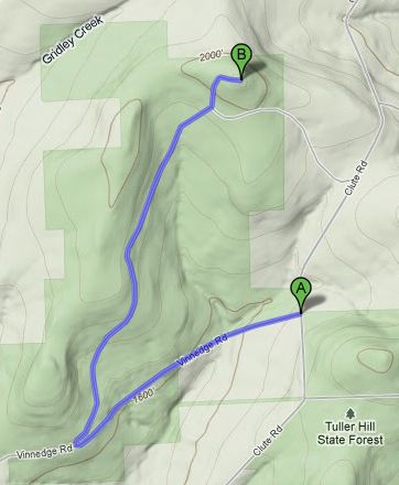
Mon: Forest roads in Tuller Hill S.F. (6 mi, 1:00)
Still feeling pretty tired and sore from the 50k, I ran at a leisurely pace and checked out some new terrain on the west side of Tuller Hill State Forest, including some segments of the Virgil Crest Ultras course. Starting at the big parking lot on Clute Road, I headed west on Vinnedge Road then took a right on another forest road that climbs a fairly big hill to a radio tower. A dense system of equestrian trails intersects the roads in many places- something to check out in the future, though I'm generally no fan of horse trails.
These are pretty nice as far as forest roads go- shaded, rocky, and passing through some nice woods. There are decent views south to Greek Peak ski area and north to the Tioughnioga River valley at a power line cut near the top of the hill, though they are obscured by the power lines.
Tues: rest
Wed: Wilderness-Bog Loop at Lime Hollow (~6 mi)
This was my first real run at Lime Hollow since my quad-loop run a few weeks ago. The trails were totally dry for the first time all year, but the bugs were insanely bad. One of my favorite things about running, rather than hiking, on trails is that the bugs barely ever bother me. Today they were inescapable, and they encouraged me to keep a fast pace to avoid being totally swarmed.
Thurs: Hill and speed work
1 mile at SUNY Cortland track (5:28) and two hill sets at Beaudry Park.
Fri: rest
Sat: Greek Peak hills and Finger Lakes Trail (16 mi, 4000 ft gain, 3:15)
This run satisfied two of my trail running needs: 1) climb the biggest hills possible in preparation for the Escarpment Trail run, and 2) get to know the Virgil Crest Ultras course, which I volunteered to help mark this fall.
The route covered sections 3 and 4 of the Virgil Crest Ultras course, beginning with a loop on ski trails at Greek Peak and then following the Finger Lakes Trail from Tone Road to the Rockpile and back. I'm very familiar with this portion of the FLT, but I knew it would be tricky following the correct ski trails without any markings. I did my best to study the description on the Virgil Crest website and the Greek Peak trail map, but I still got off course, treating myself to some extra climbing on overgrown black diamond ski slopes.
While it offered everything I wished for in terms of vertical relief, the Greek Peak section was otherwise disappointing. The trails were overgrown in most places, and in some sections the vegetation was more than waist high. I did the plants a service by assisting in their seed dispersal, as thousands of tiny seeds and other bits of plant tissue stuck to my sweaty body. I would definitely not run these trails again in this condition, though I imagine they get cleared for the race.
The 900 ft climb from Tone Road to Virgil Mountain on the FLT was much more enjoyable, though the forest on top of the hill has been thoroughly decimated by very recent logging. This was just another reminder that state forests are anything but nature preserves, and that the aesthetic quality of hiking trails is not a high priority.
The rest of the run out to the Rockpile was pleasant and uneventful. I stopped to enjoy the view on this sunny day, then retraced my steps back to the car. The climb back up Virgil Mountain was a bit of a beast, but I managed to run it all, and I let loose on the final descent to Tone Road to give my quads a good beating. Another hard trail run in the bag.
Sun: Lime Hollow (~45 min)
An easy trail run to wrap up the week. I put together a nice loop mostly on trails left out of my usual Lime Hollow route. Lehigh Valley - Phillips Memorial - Gracie Road - Bog Spur - Mill Pond - Mill Pond Connector - Hermit's Way - Fenway - ski trail - Lehigh Valley - Hawthorn - High Vista - Lookout Connector - Fenway - Lehigh Valley.
Mon: Forest roads in Tuller Hill S.F. (6 mi, 1:00)
Still feeling pretty tired and sore from the 50k, I ran at a leisurely pace and checked out some new terrain on the west side of Tuller Hill State Forest, including some segments of the Virgil Crest Ultras course. Starting at the big parking lot on Clute Road, I headed west on Vinnedge Road then took a right on another forest road that climbs a fairly big hill to a radio tower. A dense system of equestrian trails intersects the roads in many places- something to check out in the future, though I'm generally no fan of horse trails.
 |
| My route |
Tues: rest
Wed: Wilderness-Bog Loop at Lime Hollow (~6 mi)
This was my first real run at Lime Hollow since my quad-loop run a few weeks ago. The trails were totally dry for the first time all year, but the bugs were insanely bad. One of my favorite things about running, rather than hiking, on trails is that the bugs barely ever bother me. Today they were inescapable, and they encouraged me to keep a fast pace to avoid being totally swarmed.
Thurs: Hill and speed work
1 mile at SUNY Cortland track (5:28) and two hill sets at Beaudry Park.
Fri: rest
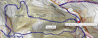
Sat: Greek Peak hills and Finger Lakes Trail (16 mi, 4000 ft gain, 3:15)
This run satisfied two of my trail running needs: 1) climb the biggest hills possible in preparation for the Escarpment Trail run, and 2) get to know the Virgil Crest Ultras course, which I volunteered to help mark this fall.
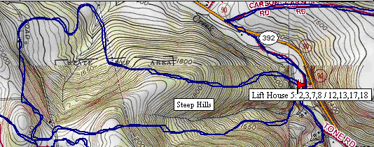
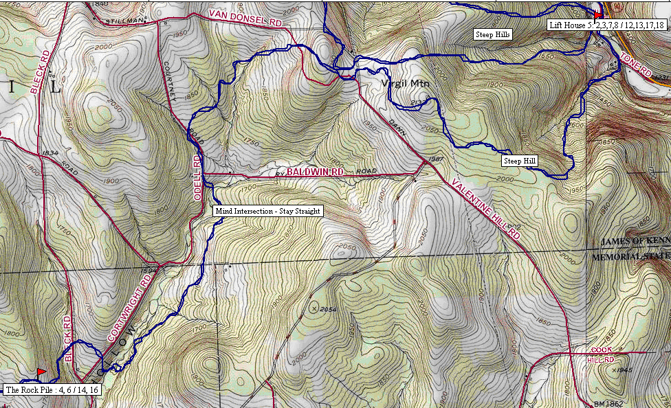 |
| Maps of Section 3- Lift House 5 loop (top) and Section 4- Lift House 5 to Rockpile (bottom) of the Virgil Crest Ultras course (courtesy of the race website) |
The route covered sections 3 and 4 of the Virgil Crest Ultras course, beginning with a loop on ski trails at Greek Peak and then following the Finger Lakes Trail from Tone Road to the Rockpile and back. I'm very familiar with this portion of the FLT, but I knew it would be tricky following the correct ski trails without any markings. I did my best to study the description on the Virgil Crest website and the Greek Peak trail map, but I still got off course, treating myself to some extra climbing on overgrown black diamond ski slopes.
While it offered everything I wished for in terms of vertical relief, the Greek Peak section was otherwise disappointing. The trails were overgrown in most places, and in some sections the vegetation was more than waist high. I did the plants a service by assisting in their seed dispersal, as thousands of tiny seeds and other bits of plant tissue stuck to my sweaty body. I would definitely not run these trails again in this condition, though I imagine they get cleared for the race.
The 900 ft climb from Tone Road to Virgil Mountain on the FLT was much more enjoyable, though the forest on top of the hill has been thoroughly decimated by very recent logging. This was just another reminder that state forests are anything but nature preserves, and that the aesthetic quality of hiking trails is not a high priority.
The rest of the run out to the Rockpile was pleasant and uneventful. I stopped to enjoy the view on this sunny day, then retraced my steps back to the car. The climb back up Virgil Mountain was a bit of a beast, but I managed to run it all, and I let loose on the final descent to Tone Road to give my quads a good beating. Another hard trail run in the bag.
Sun: Lime Hollow (~45 min)
An easy trail run to wrap up the week. I put together a nice loop mostly on trails left out of my usual Lime Hollow route. Lehigh Valley - Phillips Memorial - Gracie Road - Bog Spur - Mill Pond - Mill Pond Connector - Hermit's Way - Fenway - ski trail - Lehigh Valley - Hawthorn - High Vista - Lookout Connector - Fenway - Lehigh Valley.
Sunday, July 3, 2011
Finger Lakes 50s Race Report
As I shuffled along about half way through the second loop of the Finger Lakes 50s course, my left groin cramping every few steps, my stomach unwilling to accept food, and my energy sapped by the heat and humidity, I imagined how I would describe my experience to family and friends. One sentence seemed like it would capture it well: "It was so hard."
Waiting at the starting line, I wasn't thinking about how hard the race would be. I was just excited, after many months of training, to start my first ultra. Finally the cowbells rang out and I charged with the rest of the field down Potomac Road and into the woods, happy to be running.
The Finger Lakes 50s course is a 16.5 mi loop in Finger Lakes National Forest on the high ridge separating Cayuga and Seneca Lakes (the 50k, which I was running, consists of two loops). The loop runs through forests and meadows on top of the ridge, occasionally dropping down one of the many gorges created by streams that flow down to the lakes. The most famous and unique features, of course, are the cows that make their home in several of the fields and the gates keeping them in, which runners must open and close along the way.
 |
| Map of Finger Lakes Fifties course (may not be 100% accurate) |
I felt very fresh and ran at a fairly fast pace along the Burnt Hill Trail and through the first field, which was bathed in golden light by the rising sun shining through the morning haze. Next the trail swung onto dirt Mark Smith Road, where I found myself at the front of a handful of runners for the long descent to the first aid station.
Here we took a sharp right and climbed back up the ridge on the Gorge Trail. This was one of my favorite sections of the course- a rocky, rooted singletrack trail through deep shade on the edge of a narrow ravine. I ran the climb except for a couple short, steep sections, exchanging positions with a couple runners along the way.
Back on top of the ridge, we passed by a couple ponds and the second aid station, then began my favorite part of the entire race, dropping down the south end of the ridge on the Interloken and Finger Lakes Trails. This was a long roller coaster descent on singletrack trails with a perfect pitch for fast downhill running, and I bombed down with local runner Scott J. and Colorado law student Zach on my tail, knowing they must be having as much fun as me.
At the bottom of the hill I changed gears and the three of us made the gradual climb on trails and dirt roads back to the second aid station, near the halfway point of the loop. From there, the trail ran north along the ridge on the Interloken Trail to the second open field, which provided vast views to the west across Seneca Lake (though the lake itself, tucked in its steep glacial valley, wasn't visible). At this point, I was alone and tried to settle into a steady pace.
After passing the third aid station, the trail made another detour off the ridge, dropping down and back up the Ravine Trail. This section was very nice, similar to the Gorge Trail, and a welcome change from the flat, ridge-top running. Next came a short segment of paved road and a left turn onto the Backbone Trail- easily my least favorite part of the course.
This horse trail was perfectly straight, mostly flat, exposed to the sun, and frequently interrupted by unavoidable patches of thick, heavy mud. As I hate running with wet feet, I tried overly hard to avoid the mud, and Zach from Colorado caught me again. He decided to run with me for a while, and the opportunity to chat with someone made this long section go by somewhat more quickly. We ran together through the last aid station, through another field, and finally back onto real singletrack on the Interloken Trail.
Excited to be back on a nice trail in the woods and close to the end of the first loop, I maintained a good pace through this section, which included some very large roots, long wooden boardwalks, and several more ponds. I even spotted a turtle sunny itself next to the trail, and I made sure to keep my eye out for more, not wanting to stomp on any wildlife.
We finally cruised into the Potomac Campsite and the end of the first loop in 2:23. My conservative goal was to finish in 5:30, but in the back of my mind I thought I had a slight chance at 5:00. Now, halfway through, I was well under even that more ambitious pace and feeling pretty good. I quickly grabbed some gels and my mp3 player from my drop bag and headed back out, determined to keep a strong pace that would get me a sub 5 hour finish.
This illusion lasted several miles into the second loop. I took it relatively easy on the downhill on Mark Smith Road, not wanting to trash my quads. I managed the climb up the Gorge Trail fairly well, though I did a lot more walking than the first time around. This is also when I started having trouble taking in food- it took me at least 15 minutes to force down a single GU. At the top of the hill, the first hints of cramping started in my left groin, and I was forced to drastically slow my pace. Several runners passed me, and I began reevaluating my goals. Sub 5 hours was out of the question- I now just wanted a respectable finish.
My low point occurred at the bottom of the hill that had been such a blast to run on the first loop. I stopped at a bridge to stretch my right quad, but before I had brought my foot all the way up, bam! - huge cramp. Everything was feeling horrible at this point, the weather was getting really hot, I was low on fluids because I stupidly forgot to refill my bottle at the last aid station, and I started to doubt my ability to make it past the upcoming hill and remaining 10 miles of the course in anything but a pathetic, miserable walk.
This being my first ultra, I had never found myself in this position, but I thought of the story of ultra hero Geoff Roes in last year's Western States 100. He had hit a real low point midway through that race but had the mental strength to slow down, regroup, and recover, and ended up smoking the last portion of the race en route to a course record. Maybe my low point was also temporary, and I would start feeling better. I resolved to keep moving as best I could and keep hoping that I could turn things around.
I plugged away up the hill, through an aid station, and along the ridge on the Interloken Trail, though the cramping continued and I still felt generally lousy. A runner whose name I didn't catch caught me soon after the second field and passed me on the Ravine Trail, but I at least I had found a pace- somewhere between a jog and a slow run- that I could manage. At the beginning of the Backbone Trail, I pulled even with the runner again, and we ran together and chatted for a while.
Suddenly, at the top of a little rise, I found that I could pick up my pace considerably, and I burst ahead. Maybe now things were turning around! I kept this up for several minutes, but the cramping started to come back, and I slowed down again on the long, hot slog the rest of the way up the Backbone Trail. I was caught coming into the last aid station, but the knowledge that I was almost through the exposed sections and near the finish lifted my spirits a bit. I downed some soda and started power hiking up the last field, telling myself that I would run strong once back in the woods.
This final section went as well as could be expected under the circumstances. My pace was jointly limited by general fatigue and pain and my ability to move my legs without my left groin cramping, but it was at least a steady run. I passed many 25k runners as I chugged through the woods, past the ponds, and into the campground, reaching the finish in 5:23:17, utterly worn out and mentally dazed.
I had wondered how I would feel upon finishing my first ultra, but there was no rush of euphoria or even relief. I was in pretty bad shape- not running felt only slightly better than running, and neither food nor drink held any appeal for me. Feelings of satisfaction and pride eventually came but had to wait for my body to start feeling okay (this required taking a nap).
It is rewarding to be able to say to myself "I ran an ultra," but as a reason for running, this sense of accomplishment takes a back seat to the pure enjoyment of actually being out on the trails. Though what I felt during the last couple hours of this race couldn't be described as "enjoyment" in the typical sense, running 50 km gave me a chance to challenge myself in a way I've never experienced, and I'm proud of the way I handled it.
Monday, June 27, 2011
Weekly Summary: June 20-26
This week I started to taper for the upcoming Finger Lakes 50s, so only four days of running, but I did get in a nice race at Forge the Gorgeous and a longish trail run on the Finger Lakes Trail.
Mon: rest
Tues: Beaudry Park hills and high school trails (1 hr)
Urban trail run consisting of one hill set at Beaudry Park, some meandering on the trails by the Cortland high school, and another hill set.
Wed: Blue Creek loop (6 mi)
This is one of my standard road runs in Cortland. It gets out of the city fairly quickly and features a couple small hills and pleasant views.
Thurs: Forge the Gorgeous (7 mi, 55:31, 8th/108)
This was a fast, fun, and scenic local race with a good amount of climbing. Check out my race report.
Fri: rest
Saturday: Trail run in Kennedy S.F. (14 mi, ~2:30)
The Finger Lakes Trail in Kennedy State Forest south of Cortland keeps sprouting loop trails, creating many interesting options for running routes, and I utilized three of them on this run: the well established Dabe's Diversion Loop and the newly constructed Swedish and Lithuanian Loops. Check the bottom of this page from cnyhiking.com for a nice map of these trails.
Parking at the intersection of Hauck Hill Rd. and Bleck Rd., I headed south on the Dabe's Diversion Loop to the rockpile, where the extreme humidity made for a hazy view, and then turned west on the FLT. Now that it's mid-summer, the foliage is incredibly dense in some places, and coupled with thick cloud cover this made for twilight-like light levels during the middle of the day. I found myself slowing down at times due to the low light.
About halfway down the hill to Babcock Hollow Rd., the Lithuanian Loop trail splits off to the right, descending to the road a little bit north of where it intersects the main FLT, then traversing back uphill to meet the FLT again only 0.1 mile below where it first split off. It makes for an interesting little 1 mile diversion, including a section that weaves through a dense, uniformly spaced pine plantation with a smooth bed of pine needles.
After rejoining the FLT and running in and out of Babcock Hollow and over the next ridge, I took a right on the Swedish Loop, which climbs 0.5 mi on Bell-Hilsinger Rd. and then begins the descent to Daisy Hollow, rejoining the FLT half way down. This was a great section of singletrack trail, well cleared and passing through some nice forest (it also bypasses the climb up Owego Hill- a good or bad thing depending on your perspective).
Once back on the FLT, I ran down to Daisy Hollow, then turned around and followed the white blazes all the way back to the rockpile, then up the Dabe's Diversion Loop to my car. I got rained on a bit and ended with soaked feet as usual, despite the best efforts of my new Drymax sock ("#1 sock to keep feet dry"). So ended my last long trail run before the Finger Lakes 50s. I took it relatively easy, felt very good, and enjoyed both the new and familiar trails.
I also have some ideas for a Kennedy State Forest mega-route, incorporating the entire FLT from Daisy Hollow to Tone Road plus the Irvin, Spanish, Swedish, Lithuanian, Dabe's Diversion, and Virgil Mountain Loops. Looking forward to that!
Mon: rest
Tues: Beaudry Park hills and high school trails (1 hr)
Urban trail run consisting of one hill set at Beaudry Park, some meandering on the trails by the Cortland high school, and another hill set.
Wed: Blue Creek loop (6 mi)
This is one of my standard road runs in Cortland. It gets out of the city fairly quickly and features a couple small hills and pleasant views.
 |
| Blue Creek loop |
Thurs: Forge the Gorgeous (7 mi, 55:31, 8th/108)
This was a fast, fun, and scenic local race with a good amount of climbing. Check out my race report.
Fri: rest
Saturday: Trail run in Kennedy S.F. (14 mi, ~2:30)
The Finger Lakes Trail in Kennedy State Forest south of Cortland keeps sprouting loop trails, creating many interesting options for running routes, and I utilized three of them on this run: the well established Dabe's Diversion Loop and the newly constructed Swedish and Lithuanian Loops. Check the bottom of this page from cnyhiking.com for a nice map of these trails.
Parking at the intersection of Hauck Hill Rd. and Bleck Rd., I headed south on the Dabe's Diversion Loop to the rockpile, where the extreme humidity made for a hazy view, and then turned west on the FLT. Now that it's mid-summer, the foliage is incredibly dense in some places, and coupled with thick cloud cover this made for twilight-like light levels during the middle of the day. I found myself slowing down at times due to the low light.
About halfway down the hill to Babcock Hollow Rd., the Lithuanian Loop trail splits off to the right, descending to the road a little bit north of where it intersects the main FLT, then traversing back uphill to meet the FLT again only 0.1 mile below where it first split off. It makes for an interesting little 1 mile diversion, including a section that weaves through a dense, uniformly spaced pine plantation with a smooth bed of pine needles.
After rejoining the FLT and running in and out of Babcock Hollow and over the next ridge, I took a right on the Swedish Loop, which climbs 0.5 mi on Bell-Hilsinger Rd. and then begins the descent to Daisy Hollow, rejoining the FLT half way down. This was a great section of singletrack trail, well cleared and passing through some nice forest (it also bypasses the climb up Owego Hill- a good or bad thing depending on your perspective).
Once back on the FLT, I ran down to Daisy Hollow, then turned around and followed the white blazes all the way back to the rockpile, then up the Dabe's Diversion Loop to my car. I got rained on a bit and ended with soaked feet as usual, despite the best efforts of my new Drymax sock ("#1 sock to keep feet dry"). So ended my last long trail run before the Finger Lakes 50s. I took it relatively easy, felt very good, and enjoyed both the new and familiar trails.
I also have some ideas for a Kennedy State Forest mega-route, incorporating the entire FLT from Daisy Hollow to Tone Road plus the Irvin, Spanish, Swedish, Lithuanian, Dabe's Diversion, and Virgil Mountain Loops. Looking forward to that!
Friday, June 24, 2011
Forge the Gorgeous race report
I decided semi-last minute to run this race, even though its distance (7 mi) is a little short for my liking. I had three main reasons: 1) after months of training I just wanted to run an actual race; 2) the trails are indeed gorgeous; 3) pizza at the finish line.
The race is held in Fillmore Glen State Park in Moravia, and the course consists of two partially overlapping loops, basically ascending and descending the glen twice: up the North Rim Trail, down the South Rim Trail, up the Gorge Trail, and back down the North Rim Trail.
I tend to start races slowly, but my tentative plan was to go out hard and see how long I could stay with the big guns. The race began with a sprint of several hundred yards up a grass field before crossing a bridge over the creek and starting a steep, switch-backing ascent up the North Rim Trail. At the beginning of the climb I was close to the leaders, but it was quickly apparent that I would kill myself trying to hang with them. So I found a steady pace, gradually passing a few people on the first half of the ascent.
Once the steepest part of the climb was behind me, I settled in behind Scot J., a local runner I've battled in several races, in seventh place. At this point I could no longer ignore the signals coming from my bladder and had to stop for a quick pee break- which ended up being an all-too-long pee break. Four runners passed me, but I took off up the trail feeling rejuvenated and quickly overtook three of them. Finding myself alone for the rest of the ascent, I crossed the dam, made the last climb up the other side of the gorge, and hit the turnaround.
I could see Scot and another runner maybe 50 yards ahead at the beginning of the descent down South Rim Road. I'm usually pretty fast on the downhills, so I thought I had a good chance of catching them. But about halfway down, where the course switches from pavement to the South Rim Trail, their lead seemed to be about the same, and I lost sight of them in the woods. I kept a fast but not blistering pace the rest of the way down, not wanting to destroy my quads for the upcoming climb. This made for a fun descent to the turnaround, where I saw Scot and the other runner still about 50 yards ahead and beginning up the Gorge Trail.
The Gorge Trail is definitely the scenic highlight of the race, winding its way up the bottom of the narrow glen, crossing the creek eight times on stone bridges and passing several waterfalls. I soon lost touch with the runners ahead of me, so I tried to enjoy the scenery but still push myself, knowing the race would soon be all downhill. The humidity started to get oppressive in the dank recesses of the gorge, and I was glad when it was time to make the steep climb up to the south rim, where I enjoyed a nice breeze on the final paved portion of the ascent.
I didn't see anyone ahead of or behind me when I began the final descent on the North Rim Trail, so I figured I might be alone for the rest of the race. This was fine by me. Last year, with the opportunity to pass a few people, I had pushed really hard the entire way, including a borderline-reckless plunge down the final section of steep, loose-rock-covered trail, uneven stone steps, and hairpin turns. This time, I ran hard but didn't totally abandon myself to gravity. The descent ends abruptly with a sharp turn leading to a last bridge over the creek and a grassy dash to the finish. I saw Scot on the other side of the bridge and knew I wouldn't catch him, but I went all out on the final sprint for an 8th place finish in 55:31.
In summary, it was a great race on beautiful trails with delicious pizza at the finish, and I'm definitely glad I decided to run it. Despite the humidity, pee break, and lack of urgency on the last downhill, I improved on my time from last year, making me feel pretty good about my condition heading into next weekend's Finger Lakes 50s. Can't wait!
The race is held in Fillmore Glen State Park in Moravia, and the course consists of two partially overlapping loops, basically ascending and descending the glen twice: up the North Rim Trail, down the South Rim Trail, up the Gorge Trail, and back down the North Rim Trail.
 |
| Map of Forge the Gorgeous course with first loop in red and second loop in orange. Not sure this is 100% accurate, but it gives the basic idea. |
I tend to start races slowly, but my tentative plan was to go out hard and see how long I could stay with the big guns. The race began with a sprint of several hundred yards up a grass field before crossing a bridge over the creek and starting a steep, switch-backing ascent up the North Rim Trail. At the beginning of the climb I was close to the leaders, but it was quickly apparent that I would kill myself trying to hang with them. So I found a steady pace, gradually passing a few people on the first half of the ascent.
Once the steepest part of the climb was behind me, I settled in behind Scot J., a local runner I've battled in several races, in seventh place. At this point I could no longer ignore the signals coming from my bladder and had to stop for a quick pee break- which ended up being an all-too-long pee break. Four runners passed me, but I took off up the trail feeling rejuvenated and quickly overtook three of them. Finding myself alone for the rest of the ascent, I crossed the dam, made the last climb up the other side of the gorge, and hit the turnaround.
I could see Scot and another runner maybe 50 yards ahead at the beginning of the descent down South Rim Road. I'm usually pretty fast on the downhills, so I thought I had a good chance of catching them. But about halfway down, where the course switches from pavement to the South Rim Trail, their lead seemed to be about the same, and I lost sight of them in the woods. I kept a fast but not blistering pace the rest of the way down, not wanting to destroy my quads for the upcoming climb. This made for a fun descent to the turnaround, where I saw Scot and the other runner still about 50 yards ahead and beginning up the Gorge Trail.
The Gorge Trail is definitely the scenic highlight of the race, winding its way up the bottom of the narrow glen, crossing the creek eight times on stone bridges and passing several waterfalls. I soon lost touch with the runners ahead of me, so I tried to enjoy the scenery but still push myself, knowing the race would soon be all downhill. The humidity started to get oppressive in the dank recesses of the gorge, and I was glad when it was time to make the steep climb up to the south rim, where I enjoyed a nice breeze on the final paved portion of the ascent.
I didn't see anyone ahead of or behind me when I began the final descent on the North Rim Trail, so I figured I might be alone for the rest of the race. This was fine by me. Last year, with the opportunity to pass a few people, I had pushed really hard the entire way, including a borderline-reckless plunge down the final section of steep, loose-rock-covered trail, uneven stone steps, and hairpin turns. This time, I ran hard but didn't totally abandon myself to gravity. The descent ends abruptly with a sharp turn leading to a last bridge over the creek and a grassy dash to the finish. I saw Scot on the other side of the bridge and knew I wouldn't catch him, but I went all out on the final sprint for an 8th place finish in 55:31.
In summary, it was a great race on beautiful trails with delicious pizza at the finish, and I'm definitely glad I decided to run it. Despite the humidity, pee break, and lack of urgency on the last downhill, I improved on my time from last year, making me feel pretty good about my condition heading into next weekend's Finger Lakes 50s. Can't wait!
Thursday, June 23, 2011
Weekly Summary: June 13-19
Mon: Hill and speed work in Cortland (~5 mi)
Same as last week: easy 1 mi. jog to the track at SUNY Cortland, then a hard mile on the track (5:28, a little slower than last week), then a jog to Beaudry Park for some hills (13 total).
Tues: Tower Road (9.6 mi)
Also the same as last week, but tried to run harder on the steep parts.
Wed: Buttermilk Falls State Park (5+ mi)
I needed to run some errands in Ithaca, so I took advantage of the opportunity to run some scenic trails and check out some waterfalls. Out of the many available options, I chose a nice tour of Buttermilk Falls, running up the Rim and Bear Trails, around Treman Lake, and down the Bear and Gorge Trails. Unfortunately, I couldn't make it all the way around the lake, as just past the inlet the trail was blocked by a huge sign informing me of the life threatening dangers awaiting me on the other side. I decided to be obedient and turned around.
It's easy to get spoiled by the ubiquity of the gorges and waterfalls around Ithaca, but the Gorge Trail at Buttermilk Falls is almost ludicrously scenic by any reasonable standard. It's just one amazing waterfall after the next, any of which would be the highlight of most trails, separated by equally beautiful sections of stream flowing over, around, and between fascinating rock formations. Not a bad run!
Thurs: Beaudry Park and High School trails (45 min)
This is my "urban trail run" in Cortland... not spectacular but better than just pavement. I began with a short jog to Beaudry Park, then up one of the sledding hills to some grassy trails meandering through quaking aspen groves. From there, I went back down the hill and over to the eastern end of the park, popped across Main Street, and started up Valley View Dr. towards the high school.
From Valley View Dr., there are a couple paths on the right leading up into the woods and a nice little trail system on high school property. I found this area last winter, and it was a pleasant surprise. After winding my way through the woods for a while I headed back home via Beaudry Park.
Fri: Rest
Sat: Long run at Lime Hollow (~24 mi, 3:42)
I planned this as my climactic long training run before the Finger Lakes Fifties (I'm running the 50k) in two weeks. The trails at Lime Hollow seem similar to those that make up the FL50s course from what I gather- some hills but not too steep, some rocks and roots but not too technical, mostly woods but some open meadows- so this seemed like a good way to prepare.
I repeated the Wilderness-Bog loop four times in alternating directions, with some variations thrown in to keep things interesting. I felt absolutely fantastic through three loops, and started to have visions of running the 50 miler instead of the 50k- dangerous thoughts to think before even cracking 20 miles. I started to feel it on the fourth loop but finished strong and encouraged about my chances of having a good race at the FL50s.
Sun: Roads and trails in Ithaca (40 min)
I found myself in Ithaca again with some time for a short run- time for more waterfalls and gorges! I parked on Lake Street and made the short trip up to Ithaca Falls. I had forgotten how impressive it is when there is a decent amount of water- this is a serious waterfall.
Next, I headed south on streets to the base of Cascadilla Glen (just another incredibly scenic gorge containing at least a half dozen waterfalls), with the plan of running up to and then across Cornell campus and back down the Fall Creek gorge to my car. Unfortunately, the trail was closed halfway up the glen, so I reluctantly turned around and made my way up the hill to campus by various roads and staircases.
Heading north across campus, I made my way to the suspension bridge across Fall Creek (also closed) and headed down the gorge on the Cayuga Trail for views of yet more waterfalls. I stopped at the Stewart Street bridge for a view of the deepest, most spectacular part of the gorge, then followed roads back down to my car.
Same as last week: easy 1 mi. jog to the track at SUNY Cortland, then a hard mile on the track (5:28, a little slower than last week), then a jog to Beaudry Park for some hills (13 total).
Tues: Tower Road (9.6 mi)
Also the same as last week, but tried to run harder on the steep parts.
Wed: Buttermilk Falls State Park (5+ mi)
I needed to run some errands in Ithaca, so I took advantage of the opportunity to run some scenic trails and check out some waterfalls. Out of the many available options, I chose a nice tour of Buttermilk Falls, running up the Rim and Bear Trails, around Treman Lake, and down the Bear and Gorge Trails. Unfortunately, I couldn't make it all the way around the lake, as just past the inlet the trail was blocked by a huge sign informing me of the life threatening dangers awaiting me on the other side. I decided to be obedient and turned around.
 |
| Map of Buttermilk Falls State Park- red dots indicate my route. |
It's easy to get spoiled by the ubiquity of the gorges and waterfalls around Ithaca, but the Gorge Trail at Buttermilk Falls is almost ludicrously scenic by any reasonable standard. It's just one amazing waterfall after the next, any of which would be the highlight of most trails, separated by equally beautiful sections of stream flowing over, around, and between fascinating rock formations. Not a bad run!
Thurs: Beaudry Park and High School trails (45 min)
This is my "urban trail run" in Cortland... not spectacular but better than just pavement. I began with a short jog to Beaudry Park, then up one of the sledding hills to some grassy trails meandering through quaking aspen groves. From there, I went back down the hill and over to the eastern end of the park, popped across Main Street, and started up Valley View Dr. towards the high school.
From Valley View Dr., there are a couple paths on the right leading up into the woods and a nice little trail system on high school property. I found this area last winter, and it was a pleasant surprise. After winding my way through the woods for a while I headed back home via Beaudry Park.
Fri: Rest
Sat: Long run at Lime Hollow (~24 mi, 3:42)
I planned this as my climactic long training run before the Finger Lakes Fifties (I'm running the 50k) in two weeks. The trails at Lime Hollow seem similar to those that make up the FL50s course from what I gather- some hills but not too steep, some rocks and roots but not too technical, mostly woods but some open meadows- so this seemed like a good way to prepare.
I repeated the Wilderness-Bog loop four times in alternating directions, with some variations thrown in to keep things interesting. I felt absolutely fantastic through three loops, and started to have visions of running the 50 miler instead of the 50k- dangerous thoughts to think before even cracking 20 miles. I started to feel it on the fourth loop but finished strong and encouraged about my chances of having a good race at the FL50s.
Sun: Roads and trails in Ithaca (40 min)
I found myself in Ithaca again with some time for a short run- time for more waterfalls and gorges! I parked on Lake Street and made the short trip up to Ithaca Falls. I had forgotten how impressive it is when there is a decent amount of water- this is a serious waterfall.
Next, I headed south on streets to the base of Cascadilla Glen (just another incredibly scenic gorge containing at least a half dozen waterfalls), with the plan of running up to and then across Cornell campus and back down the Fall Creek gorge to my car. Unfortunately, the trail was closed halfway up the glen, so I reluctantly turned around and made my way up the hill to campus by various roads and staircases.
Heading north across campus, I made my way to the suspension bridge across Fall Creek (also closed) and headed down the gorge on the Cayuga Trail for views of yet more waterfalls. I stopped at the Stewart Street bridge for a view of the deepest, most spectacular part of the gorge, then followed roads back down to my car.
Friday, June 17, 2011
Getting to the bottom of Cortland's seven valleys
In my last post, I noted that one of my running routes provides "nice views of Cortland and its seven valleys." The term "seven valleys" gets applied to a lot of businesses and things in Cortland, and Wikipedia refers to Cortland's "location on a plain formed by the convergence of seven valleys." However, I wasn't sure which valleys make up the seven, or if there even are that many. So I decided to poke around on Google maps and try to figure this out.
The results of this search were fairly satisfying, though not totally unambiguous. Here is a map with the valleys I could identify, numbered according to my subjective assessment of their legitimacy:

1. West Branch Tioughnioga River/I-81. This is a classic U-shaped glacial valley running all the way up to Syracuse. Yep, it counts.
2. East Branch Tioughnioga River/Rt. 13. Another well-defined valley with very flat bottom and relatively steep hills in either side.
3. Tioughnioga River/I-81. All the other valleys in Cortland drain into this one, which leads to the Chenango River, then the Susquehanna, then the Chesapeake Bay and Atlantic Ocean.
4. Trout Brook/Rt. 41. This one is also pretty clear-cut, and you definitely feel like you're in a valley when driving up Rt. 41.
5. Otter Creek/Beaver Creek/Rt. 13. Very broad but not particularly well-defined. Otter Creek flows northeast towards Cortland, but Beaver Creek flows southwest into Fall Creek and on to Ithaca. The divide is just east of Lime Hollow.
6. Factory Brook/Rt. 41. This is a very nice valley- it holds Skaneateles Lake- so I'd like to count it. The only issue is that it converges with the the W. Branch Tioughnioga valley in Homer, so it's technically not it Cortland. But close enough.
7. Dry Creek/Kinney Gulf. While not very long, this is the only valley that has a name I'm aware of, plus the sides are fairly steep and it carries a decent creek.
8 and 9. These two are definitely sketchy. They are both clearly valleys, but neither carries a named stream or is very impressive. The only reason I'd count one of these is if the Factory Brook valley (#6) were disqualified for not really being in Cortland.
Monday, June 13, 2011
Weekly Summary: June 6-12
Mon: Hill and speed work in Cortland (~5 mi)
This is one of my regular workouts, consisting of a 1 mile jog to the old track at SUNY Cortland, a hard mile on the track (5:26), then a jog to Beaudry Park, where there is a small hill with a set of 6 decently steep sledding trails. 2 hill sets today then back home.


This is one of my regular workouts, consisting of a 1 mile jog to the old track at SUNY Cortland, a hard mile on the track (5:26), then a jog to Beaudry Park, where there is a small hill with a set of 6 decently steep sledding trails. 2 hill sets today then back home.

Beaudry Park and its gnarly hills.
Tues: Tower Road (9.6 mi)
This has become my standard midweek longish road run. It features a few stiff climbs (first on Pendleton St. up to Ahrens Rd., a second push up to Tower Rd., and a final ascent to the eponymous tower), nice views of Cortland and its seven valleys (not sure how they arrived at that number), and a respectable-for-central-NY 2000 ft "summit". It tends to be insanely humid whenever I do this run...
The route from my house to the top of Tower Rd. I usually go up Pendleton St. (steeper) and down Page Green.
Wed: Road bike (8.6 mi round trip) and Wilderness-Bog Loop (~6 mi)
Other than the couple weeks I get fired up each year around the Tour de France, I'm not that into road biking, but with the car in the shop it was my only means of transport to the trails at Lime Hollow. It was nice to mix things up, though, and refreshing to get to the trailhead and back under my own power.
Thurs: rest
Fri: New Lehigh Valley Trail and Chicago Bog (~6 mi)
Since I have moved to Cortland, several new things have been constructed, mostly to my disappointment: a KFC, a super Walmart, an overpriced pizza place. The newest addition, a 2.7 mi extension of the Lehigh Valley Trail east from Lime Hollow, is more to my liking. I had checked this out earlier in the spring, but the western end of the trail by Gracie Road was totally flooded, apparently due to the work of beavers. In the end, though, they were no match for human trail crews. The trail is now terrestrial and ready for recreational enjoyment.
As a former railway, the trail is of course pancake flat and arrow straight, but enjoyable nonetheless. From Lime Hollow, the trail passes through some nice forest with lots of shade and later skirts by several small ponds. A number of paths intersect the trail. Most are snowmobile and ATV trails, which I assume are on private property, but one leads to Chicago Bog, creating some nice loop and link-up options, including a potential modification to the Wilderness-Bog Loop that would remove the short road section.
In summary, this is a welcome addition to the Cortland trail scene and a good choice for a flat, fast, unpaved run.
Sat: Finger Lakes Trail in Kennedy State Forest (21.1 mi, ~4500' gain, ~4:00)
The 459-mile Finger Lakes Trail (part of the 4,600-mile North Country Trail) winds through several state forests near Cortland, providing opportunities for long, hilly trail runs. This run covered most of the FLT in Kennedy State Forest, including portions of trail used in several local races (Forest Frolic, Monster Marathon, Virgil Crest Ultras).
Starting at the intersection of Bleck Rd. and the FLT, the route was basically a double out-and-back: first west to Daisy Hollow (11 mi), then east to Tone Rd., with a detour on the Virgil Mountain Loop on the way back (10.1 mi).
The first portion (Bleck Rd. to Daisy Hollow) is my favorite segment of the FLT in Cortland County. There is a great view, a rarity in the area, from the Rockpile at the intersection with Dabe's Diversion Loop (see below). The trail is all narrow singletrack through nice forest (no recent logging as far as I can tell), free of the tall, foot-soaking and leg-scratching grasses and other vegetation that plague many segments of the FLT. There is a series of decent-sized hills as the trail goes against the grain of the north-south oriented ridges and hollows. The climb heading west out of Babcock Hollow is especially tough, with some very steep, off-camber sections and difficult footing.
 |
| View from the Rockpile (me with Remi last fall) |
The second portion (Bleck Rd. to Tone Rd.) is notable in that it includes the highest point (Virgil Mountain, 2132 ft.) and the biggest climb I'm aware of (Tone Rd. to Virgil Mountain, almost 900 ft.) in Cortland County. Unfortunately, some portions of the trail are in poor condition due to logging and defoliation by gypsy moths. In particular, the segment climbing up Greek Peak between O'Dell Rd. and Van Donsel Rd., which I used to really enjoy, was logged earlier this year, leaving the trail muddy and overgrown... thanks, DEC. I complain too much, though. Most of the trail is nice, especially the beginning of the climb up Tone Rd., which parallels a steep mountain stream with several small waterfalls when the water is up.
In the end, this ended up being a pretty beastly run for me, with all the hills adding up to a respectable 4500 ft. of elevation gain. I felt good and had no major problems throughout- a good way to end the week.
Subscribe to:
Posts (Atom)